Galileo is a global navigation satellite system (GNSS) currently being built by the European Union (EU) and
European Space Agency (ESA). The €5 billion
project is named after the Italian astronomer Galileo
Galilei. One of the aims of Galileo is to provide a high-precision positioning system upon which European nations can rely, independently from the
Russian GLONASS, US GPS, and Chinese Compass systems, which can be disabled in times of war or
conflict.
When in operation, it will use two ground operations centers near Munich, Germany and in Fucino,
Italy. In December 2010, EU ministers in
Brussels voted Prague, Czech Republic as the headquarters of the Galileo project.
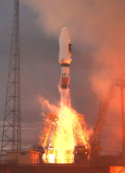
On 21 October 2011, the first two of four operational satellites were launched to validate the system. The next two followed on 12 October 2012, making it "possible to test Galileo end-to-end". Once this In-Orbit Validation (IOV) phase has been completed, additional satellites will be launched to reach Initial Operational Capability (IOC) around mid-decade. Full completion of the 30-satellite Galileo system (27 operational and three active spares) is expected by 2019.
Basic navigation services will be free of charge. Galileo is intended to provide horizontal and vertical position measurements within 1 meter precision, and better positioning services at high latitudes than other positioning systems. As a further feature, Galileo will provide a unique global search and rescue
(SAR) function. Satellites will be equipped with a transponder which will relay distress signals from the user's transmitter to the Rescue Co-ordination Centre, which will then initiate the rescue operation. At the same time, the system will provide a signal to the users, informing them that their situation has been detected and that help is on the way. This latter feature is new and is considered a major upgrade compared to the existing
GPS and GLONASS navigation systems, which do not provide feedback to the
user. The use of basic (low-precision) Galileo services will be free and open to everyone. The high-precision capabilities will be available for paying commercial users and for military
use.
The first satellites bear the names of eleven-year-old Thijs from Belgium and nine-year-old Natalia from
Bulgaria, who are the first winners of the European Commission's Galileo children's drawing competition. Competition winners from the remaining 25 Member States will name the satellites which will be launched until 2019.
History
- Main objectives
In 1999, the different concepts (from Germany, France, Italy and the United Kingdom) for Galileo were compared and reduced to one by a joint team of engineers from all four countries. The first stage of the Galileo programme was agreed upon officially on 26 May 2003 by the
European Union and the European Space
Agency.
The system is intended primarily for civilian use, unlike the United States system, which the
U.S. military runs and uses on a primary basis. The U.S. reserves the right to limit the signal strength or precision of GPS, or to shut down public GPS access completely, so that only the
U.S. military and its allies would be able to use it in time of
conflict. The European system will only be subject to shutdown for military purposes in extreme circumstances. It will be available at its full precision to both civil and military users.
Until 2000 the precision of the GPS signal available to non-U.S.-military users was deliberately severely limited by a timing pulse distortion process known as selective availability.
Funding
The European Commission had some difficulty funding the project's next stage, after several allegedly "per annum" sales projection graphs for the project were exposed in November 2001 as "cumulative" projections (which for each year projected, necessarily included all previous years of sales). The attention that was brought to this multi-billion
euro exponentially growing error in sales forecasts resulted in a general awareness in the Commission and elsewhere that it was unlikely that the program would yield the return on investment that had previously been suggested to investors and decision-makers.
Additionally, following the September 11, 2001 attacks, the United States Government wrote to the European Union opposing the project, arguing that it would end the ability of the United States to shut down satellite navigation in times of military operations. On 17 January 2002 a spokesman for the project stated that, as a result of U.S. pressure and economic difficulties, "Galileo is almost dead."
A few months later, however, the situation changed dramatically. European Union member states decided it was important to have a satellite-based positioning and timing infrastructure that the US could not easily turn off in times of political conflict.
The European Union and the European Space Agency agreed in March 2002 to fund the project, pending a review in 2003 (which was finalised on 26 May 2003). The starting cost for the period ending in 2005 is estimated at €1.1 billion. The required satellites (the planned number is 30) will be launched throughout the period 2011–2014 and the system will be up and running and under civilian control from 2019. The final cost is estimated at
€3 billion, including the infrastructure on Earth, which is to be constructed in the years 2006 and 2007. The plan was for private companies and investors to invest at least two-thirds of the cost of implementation, with the EU and ESA dividing the remaining cost. An encrypted higher-bandwidth Commercial Service with improved precision would be available at an extra cost, with the base Open Service freely available to anyone with a Galileo-compatible receiver. Costs for the project have run 50% over initial estimates.
Cooperation with the United States
In June 2004, in a signed agreement with the United States, the European Union agreed to switch to a modulation known as BOC(1,1) (Binary Offset Carrier 1.1) allowing the coexistence of both
GPS and Galileo, and the future combined use of both systems.
The European Union also agreed to address the "mutual concerns related to the protection of allied and U.S. national security capabilities."
First experimental satellites: GIOVE-A and GIOVE-B
The first experimental satellite, GIOVE-A, was launched in 2005 and was followed by a second test satellite, GIOVE-B, launched in 2008. Once this In-Orbit Validation (IOV) phase was has been completed, additional satellites will be launched. On 30 November 2007 the 27 EU transportation ministers involved reached an agreement that it should be operational by 2013, but later press releases suggest it was delayed to 2014.

Funding again, governance issues
Early 2007, the EU had yet to decide how to pay for the system and the project was said to be "in deep crisis" due to lack of more public funds. German Transport Minister Wolfgang Tiefensee was particularly doubtful about the consortium's ability to end the infighting at a time when only one testbed satellite had been successfully launched.
Although a decision was yet to be reached, on 13 July 2007 EU countries discussed cutting €548m ($755m, £370m) from the union's competitiveness budget for the following year and shifting some of that cash to other parts of the financing pot, a move that could meet part of the cost of the union's Galileo satellite navigation system. European Union research and development projects could be scrapped to overcome a funding shortfall.
In November 2007, it was agreed to reallocate funds from the EU's agriculture and administration budgets and to soften the tendering process in order to invite more EU companies.
In April 2008, the EU transport ministers approved the Galileo Implementation Regulation. This allowed the €3.4bn to be released from the EU's agriculture and administration budgets. This will allow the issuing of contracts to start construction of the ground station and the satellites.
In June 2009, the European Court of Auditors published a report, pointing out governance issues, substantial delays and budget overruns that led to project stalling in 2007, leading to further delays and failures.
In October 2009, the European Commission cut the number of satellites from 28 to 22, with plans to order the remaining six at a later time. It also announced that the first OS, PRS and SoL signal will be available in 2013 and the CS and SOL sometime later. Current budget for 2006–2013 period planned for €3.4 billion was also considered as insufficient. The think tank Open Europe has estimated the total cost of Galileo from start to completion, and then running it over a 20 year period, at a €22.2 billion, which will be borne entirely by taxpayers. Under the original estimates (from 2000) this cost would have been €7.7 billion, of which only €2.6 billion was to be borne by taxpayers and the rest by private investors.
In November 2009, a ground station for Galileo was inaugurated near Kourou
(French Guiana).
The launch of the first four in-orbit validation (IOV) satellites was planned for the 2nd half of 2011, while the launch of full operational capability (FOC) satellites is planned to start in late 2012.
As of March 2010 it was verified that the budget for Galileo would only be available to provide the 4 IOV and 14 FOC satellites by 2014, with no funds currently committed to bring the constellation above this 60% capacity. Paul Verhoef, the then current satellite navigation program manager at the European Commission indicated that this limited funding would have serious consequences commenting at one point "To give you an idea, that would mean that for three weeks in the year you will not have satellite navigation" in reference to the currently proposed 18 vehicle constellation.
In July 2010 the European Commission estimated further delays and additional costs of the project to grow up to €1.5-€1.7 billion and moved the estimated date of completion to 2018. After it's completed, the system will need to be subsidized by governments at €750 million per year. An additional €1.9 billion was planned to be spent bringing the system up to the full complement of 30 satellites (27 operational + 3 active spares).
In December 2010 EU ministers in Brussels voted Prague (Czech Republic) as the headquarters of the Galileo
project. In January 2011, infrastructure costs up to 2020 were estimated at €5.3 billion. In that same month, Wikileaks revealed the opinion of CEO of German satellite company OHB-System, Berry Smutny. He is quoted saying that Galileo "is a stupid idea that primarily serves French interests". The
BBC understood €500 million (£440M) would become available to make the extra purchase, taking Europe's version of GPS from 18 operational satellites in the next few years to 24.
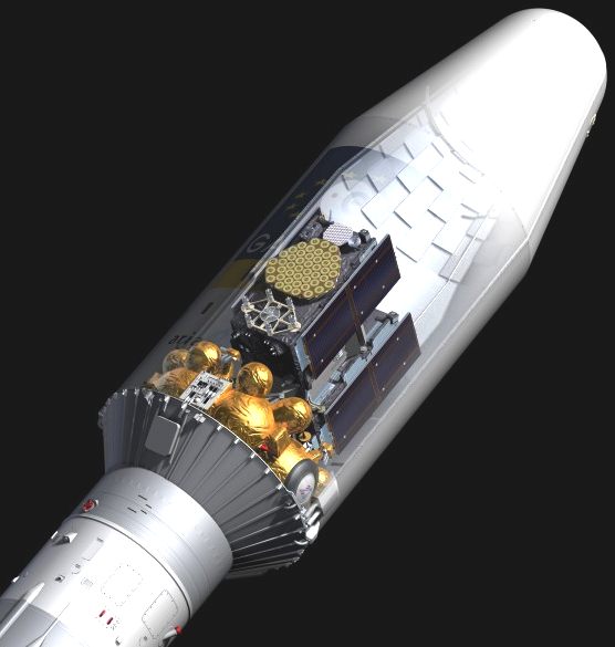
The first two Galileo In-Orbit Validation satellites were launched by Soyuz ST-B flown from Guiana Space Centre on October 21, 2011. and the remaining two on 12 October 2012.
All further satellites will have Full Operational Capability (FOC). 22 are now on order, with the first due to be launched in 2013.
In September 2003,
China joined the Galileo project. China was to invest €230 million
(USD 302 million, GBP 155 million, CNY 2.34 billion) in the project over the following years.
In July 2004, Israel signed an agreement with the EU to become a partner in the Galileo project.
On 3 June 2005 the EU and Ukraine signed an agreement for Ukraine to join the project, as noted in a press release.
As of November 2005, Morocco also joined the programme.
On 12 January 2006, South Korea joined the programme.
In November 2006, China opted instead to independently develop the Beidou navigation system satellite navigation system. When Galileo was viewed as a private-sector development with public-sector financial participation, European Commission program managers sought Chinese participation in pursuit of Chinese cash in the short term and privileged access to China’s market for positioning and timing applications in the longer term. However, due to security and technology-independence policy from European Commission, China was, in effect,
dis-invited from Galileo and without a return of its monetary investment, a decision that was reinforced by China’s move to build its own global system, called
Beidou/Compass. At the Munich Satellite Navigation Summit on March 10, a Chinese government official asked the European Commission why it no longer wanted to work with China, and when China’s cash investment in Galileo would be returned.
On 30 November 2007, the 27 member states of the European Union unanimously agreed to move forward with the project, with plans for bases in Germany and Italy. Spain did not approve during the initial vote, but approved it later that day. This greatly improves the viability of the Galileo project: "The EU's executive had previously said that if agreement was not reached by January 2008, the long-troubled project would essentially be dead."
On 3 April 2009, Norway too joined the programme pledging €68.9 million toward development costs and allowing its companies to bid for the construction contracts. Norway, while not a member of the EU, is a member of
ESA.
Political implications of Galileo project
Tension with the United States
Galileo is intended to be an EU GNSS civilian system that allows all users access to it. GPS is a US GNSS military system that provides location signals that have high precision to US military users, while also providing less precise location signals to others. The GPS had the capability to block the "civilian" signals while still being able to use the "military" signal (M-band). A primary motivation for the Galileo project was European concern that the US could deny others access to GPS during political disagreements.
Since Galileo was designed to provide the highest possible precision (greater than GPS) to anyone, the US was concerned that an enemy could use Galileo signals in military strikes against the US and its allies (some weapons like missiles use GNSS systems for guidance). The frequency initially chosen for Galileo would have made it impossible for the US to block the Galileo signals without also interfering with their own GPS signals. The US did not want to lose their GNSS capability with GPS while denying enemies the use of
GNSS. Some US officials became especially concerned when Chinese interest in Galileo was reported.
An anonymous European official claimed that the US officials implied that they might consider shooting down Galileo satellites in the event of a major conflict in which Galileo was used in attacks against American forces. The EU's stance is that Galileo is a neutral technology, available to all countries and everyone. At first, EU officials did not want to change their original plans for Galileo, but have since reached a compromise, that Galileo was to use a different frequency. This allowed the blocking/jamming of one GNSS system without affecting the other, giving the US a greater advantage in conflicts in which it has the electronic warfare upper hand. However, the frequency difference also makes it possible to jam the GPS without affecting the Galileo.
GPS and Galileo
One of the reasons given for developing Galileo as an independent system was that position information from GPS can be made significantly inaccurate by the deliberate application of universal Selective Availability (SA) by the US military; this was enabled until 2000, and can be re-enabled at any time. GPS is widely used worldwide for civilian applications; Galileo's proponents argued that civil infrastructure, including aeroplane navigation and landing, should not rely solely upon a system with this vulnerability.
On May 2, 2000, SA was disabled by President of the United States Bill Clinton; in late 2001 the entity managing the GPS confirmed that they did not intend to enable selective availability ever again. Though Selective Availability capability still exists, on 19 September 2007 the US Department of Defense announced that newer GPS
satellites would not be capable of implementing Selective Availability; the wave of Block IIF satellites launched in 2009, and all subsequent GPS satellites, do not support SA. As old satellites are replaced in the GPS Block IIIA program, SA will cease to be an option. The modernization programme also contains standardized features that allow GPS III and Galileo systems to inter-operate, allowing receivers to be developed to utilise GPS and Galileo together to create an even more precise GNSS system.
Final system description
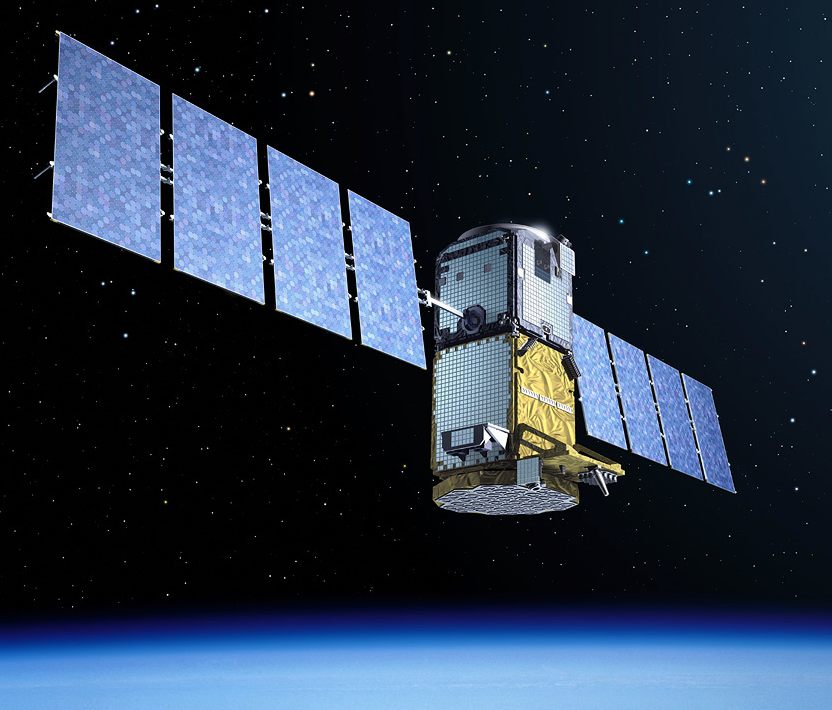
Galileo satellites
30 in-orbit spacecraft (including 3 spares)
Orbital altitude: 23,222 km (MEO)
3 orbital planes, 56° inclination, ascending nodes separated by 120° longitude (9 operational satellites and one active spare per orbital plane)
Satellite lifetime: >12 years
Satellite mass: 675 kg
Satellite body dimensions: 2.7 m × 1.2 m × 1.1 m
Span of solar arrays: 18.7 m
Power of solar arrays: 1.5 kW (end of life)
Services
*The Galileo system will have five main services:
*Open access navigation
*This will be available without charge for use by anyone with appropriate mass-market equipment; simple
timing, and positioning down to 1 metre.
*Commercial navigation (encrypted)
*High precision to the centimetre; guaranteed service for which service providers will charge fees.
Safety of life navigation
Open service; for applications where guaranteed precision is essential. Integrity messages will warn of errors.
Public regulated navigation (encrypted)
Continuous availability even if other services are disabled in time of crisis; Government agencies will be main users.
Search and rescue
System will pick up distress beacon locations; feasible to send feedback, e.g. confirming help is on its way.
Other secondary services will also be available.
The concept
Each satellite will have two rubidium atomic clocks and two passive hydrogen maser atomic clocks, critical to any satellite-navigation system, and a number of other components. The clocks will provide an
accurate timing signal to allow a receiver to calculate the time that it takes the signal to reach it. This information is used to calculate the position of the receiver by trilaterating the difference in received signals from multiple satellites.
Satellite system - Galileo satellite test beds: GIOVE
In 2004 the Galileo System Test Bed Version 1 (GSTB-V1) project validated the on-ground algorithms for Orbit Determination and Time Synchronisation (OD&TS). This project, led by ESA and European Satellite Navigation Industries, has provided industry with fundamental knowledge to develop the mission segment of the Galileo positioning system.
GIOVE-A is the first GIOVE (Galileo In-Orbit Validation Element) test satellite. It was built by Surrey Satellite Technology Ltd (SSTL), and successfully launched on 28 December 2005 by the European Space Agency and the Galileo Joint. Operation of GIOVE-A ensured that Galileo meets the frequency-filing allocation and reservation requirements for the International Telecommunication Union (ITU), a process that was required to be complete by June 2006.
GIOVE-B, built by Astrium and Thales Alenia Space, has a more advanced playload than GIOVE-A. It was successfully launched on 27 April 2008 at 22:16 UTC (4.16 a.m. Baikonur time) aboard a Soyuz-FG/Fregat rocket provided by Starsem.
A third satellite, GIOVE-A2, was originally planned to be built by SSTL for launch in the second half of 2008. Construction of GIOVE-A2 was terminated due to the successful launch and in-orbit operation of
GIOVE-B.
The GIOVE Mission segment operated by European Satellite Navigation Industries is exploiting the GIOVE-A/B satellites to provide experimental results based on real data to be used for risk mitigation for the IOV satellites that will follow on from the testbeds. ESA organised the global network of ground stations to collect the measurements of GIOVE-A/B with the use of the GETR receivers for further systematic study. GETR receivers are supplied by Septentrio as well as the first Galileo navigation receivers to be used to test the functioning of the system at further stages of its deployment. Signal analysis of GIOVE-A/B data has confirmed successful operation of all the Galileo signals with the tracking performance as expected.
In-Orbit Validation (IOV) satellites
These testbed satellites were followed by four IOV Galileo satellites that are much closer to the final Galileo satellite design. The Search & Rescue feature is not installed. The first two satellites were launched on 21 October 2011 from Guiana Space Centre using a Soyuz launcher, the other two on 12 October 2012. This enables key validation tests, since earth-based receivers such as those in cars and phones need to "see" a minimum of four satellites in order to calculate their position in three dimensions. Those 4 IOV Galileo satellites were constructed by Astrium GmbH and Thales Alenia Space. Once this In-Orbit Validation (IOV) phase has been completed, the remaining satellites will be installed to reach the Full Operational Capability.
Full Operational Capability (FOC) satellites
On 7 January 2010, it was announced that the contract to build the first 14 FOC satellites was awarded to OHB System and Surrey Satellite Technology Limited (SSTL). Fourteen satellites will be built at a cost of €566M (£510M; $811M). Arianespace will launch the satellites for a cost of €397M (£358M; $569M).
The European Commission also announced that the 85 million euro contract for system support covering industrial services required by ESA for integration and validation of the Galileo system had been awarded to Thales Alenia Space. Thales Alenia Space subcontract performances to Astrium GmbH and security to Thales Communications.
In February 2012 eight additional satellites were ordered, bringing the total to 22 FOC satellites.
Science projects using Galileo
In July 2006 an international consortium of universities and research institutions embarked on a study of potential scientific applications of the Galileo constellation. This project, named GEO6, is a broad study oriented to the general scientific community, aiming to define and implement new applications of
Galileo.
Among the various GNSS users identified by the Galileo Joint Undertaking, the GEO6 project addresses the Scientific User Community (UC).
The GEO6 project aims at fostering possible novel applications within the scientific UC of GNSS signals, and particularly of Galileo.
The AGILE project is an EU-funded project devoted to the study of the technical and commercial aspects of location-based services (LBS). It includes technical analysis of the benefits brought by Galileo (and EGNOS) and studies the hybridisation of Galileo with other positioning technologies (network-based, WLAN, etc.). Within these project, some pilot prototypes were implemented and demonstrated.
On the basis of the potential number of users, potential revenues for Galileo Operating Company or Concessionaire (GOC), international relevance, and level of innovation, a set of Priority Applications (PA) will be selected by the consortium and developed within the time-frame of the same project.
These applications will help to increase and optimise the use of the EGNOS services and the opportunities offered by the Galileo Signal Test-Bed (GSTB-V2) and the Galileo (IOV) phase.

Coins
The European Satellite Navigation project was selected as the main motif of a very high value collectors' coin: the
Austrian European Satellite Navigation commemorative coin, minted on 1 March 2006. The coin has a silver ring and gold-brown niobium "pill". In the reverse, the niobium portion depicts navigation satellites orbiting the Earth. The ring shows different modes of transport, an
airplane, a car, a container ship, a train and a lorry, for which satellite navigation was developed.
Satellite
names