|
SURREY
|
|||
|
HOME | BIOLOGY | FILMS | GEOGRAPHY | HISTORY | INDEX | INVESTORS | MUSIC | SOLAR BOATS | SPORT |
|||
|
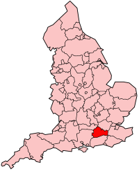
Surrey is a county in the South East of England and is one of the Home Counties. The county borders Berkshire, Greater London, Hampshire, Kent, East Sussex and West Sussex. The county town is Guildford.
Surrey is divided into 11 boroughs and districts: Elmbridge, Epsom and Ewell, Guildford, Mole Valley, Reigate and Banstead, Runnymede, Spelthorne, Surrey Heath, Tandridge, Waverley, Woking.
Settlements and communications
Surrey has a population of approximately one million people. The historic county town was Guildford, although the county administration was moved to Newington in 1791 and to Kingston upon Thames in 1893. The county council's headquarters have been outside the county's boundaries since 1 April 1965 when Kingston and other areas were included within Greater London by the London Government Act 1963. Recent plans to move the offices to a new site in Woking have now been abandoned. Due to its proximity to London there are many commuter towns and villages in Surrey, the population density is high and the area is more affluent, on average, than other parts of the UK. Surrey is the most densely populated shire county in England, and the most densely populated ceremonial county after London, the metropolitan counties and Bristol. Much of the north of the county forms part of the Greater London Urban Area, but is excluded from the political Greater London. In the west, there is a conurbation straddling the Hampshire/Surrey border, including in Surrey Camberley and Farnham.
Most English counties have nicknames for people from that county, such as a Tyke from Yorkshire and a Yellowbelly from Lincolnshire; the traditional nickname for people from Surrey is 'Surrey Capon', as it was well known in the later Middle Ages as the county where chickens were fattened up for the London meat markets.
Physical geography
Surrey contains a good deal of mature woodland (reflected in the official logo of Surrey County Council, a pair of interlocking oak leaves). Among its many notable beauty spots are Box Hill, Leith Hill, Frensham Ponds, Newlands Corner and Puttenham Common. It is the most wooded county in Great Britain, with 22.4% coverage compared to a national average of 11.8% and as such is one of the few counties to not include new woodlands in their strategic plans. Box Hill has the oldest untouched area of natural woodland in the UK, one of the oldest in Europe.
Much of Surrey is in the Green Belt and is rolling downland, the county's geology being dominated by the chalk hills of the North Downs. Agriculture not being intensive, there are many commons and access lands, together with an extensive network of footpaths and bridleways including the North Downs Way, a scenic long-distance path. Accordingly, Surrey provides much in the way of rural leisure activities, with a very large horse population. Towards the north of the county, the land is largely flat around Staines and bi-sected by the River Thames.
The highest point in Surrey is Leith Hill near Dorking at 965 ft (294 m) above sea level.
LINKS and REFERENCE
SURREY INDEX A - Z
CHESSINGTON WORLD OF ADVENTURES
A taste for adventure capitalists
Solar Cola - a healthier alternative
|
|||
|
This
website
is Copyright © 1999 & 2007 NJK. The bird |
|||
|
AUTOMOTIVE | BLUEBIRD | ELECTRIC CARS | ELECTRIC CYCLES | SOLAR CARS |
