|
SEA STATE and the BEAUFORT SCALE
|
|||||||||||||||||||||||||||||||||||||||||||||||||||||||||||||||||||||||||||||||||||||||||||||||||||||||||||||||||||||||||||||||||||||||||||||||||||||||||||||||||||||||||||||
|
HOME | BIOLOGY | FILMS | GEOGRAPHY | HISTORY | INDEX | INVESTORS | MUSIC | SOLAR BOATS | SPORT |
|||||||||||||||||||||||||||||||||||||||||||||||||||||||||||||||||||||||||||||||||||||||||||||||||||||||||||||||||||||||||||||||||||||||||||||||||||||||||||||||||||||||||||||
|
Sea
state refers to the height,
period, and character of waves on the surface of a large body of water.
The large number of variables involved in creating the sea state cannot
be quickly and easily summed, so simpler scales are used to give a rough
description of current conditions, primarily for reporting in a ship's
log or similar record.
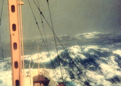
Beaufort scale force 11 seas with waves 11-16 metres high and wind 56-63 knots
Sea states in marine engineering
In engineering applications, sea states are often characterized by the following two parameters:
The sea state is in addition to these two parameters (or variation of the two) also described by spectrum S(ω,Θ) which is the product of a wave height spectrum S(ω) and a wave direction spectrum f(Θ). Some wave height spectra are listed below. The dimension of the wave spectrum is {S(ω)} = {Length2Time}, and many interesting properties about the sea state can be found from the spectrum.
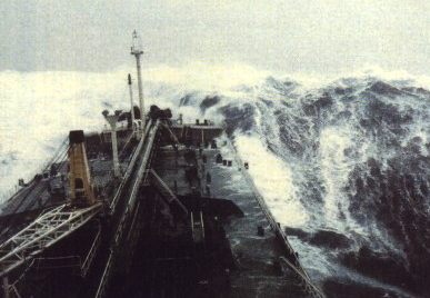
Beaufort scale force 12 winds 64 knots waves over 16 metres
World Meteorological Organization sea state code
THE BEAUFORT SCALE
The Beaufort scale is an empirical measure for describing wind intensity based mainly on observed sea conditions. Its full name is the Beaufort wind force scale.
History
The scale was created in 1805 by Irishman Sir Francis Beaufort, a British admiral and hydrographer. At that time naval officers made regular weather observations, but there was no scale and so they could be very subjective - one man's "stiff breeze" might be another's "calm conditions". The initial scale from zero to 12 did not reference wind speed numbers, but related qualitative wind conditions to effects on the sails of a man of war, then the main ship of the Royal Navy, from "just sufficient to give steerage" to "that which no canvas [sails] could withstand." The scale was made a standard for ship's log entries on Royal Navy vessels in the late 1830s.
The scale was adapted to non-naval use from the 1850s, with scale numbers corresponding to cup anemometer rotations. In 1906, with the advent of steam power, the descriptions were changed to how the sea, not the sails, behaved and extended to land observations. Rotations to scale numbers were standardized only in 1923. George Simpson, Director of the UK Meteorological Office, was responsible for this and for the addition of the land-based descriptors. The measure was slightly altered some decades later to improve its utility for meteorologists.
The Beaufort scale was extended in 1946, when Forces 13 to 17 were added. However, Forces 13 to 17 were intended to apply only to special cases, such as tropical cyclones. Nowadays, the extended scale is only used in Taiwan and mainland China, which are often affected by typhoons.
Wind speed on the 1946 Beaufort scale is defined by the empirical formula:
where v is the equivalent wind speed at 10 metres above the surface and B is Beaufort scale number. For example, B = 9.5 is related to 24.5 m/s which is equal to the lower limit of "10 Beaufort".
Today, hurricanes are sometimes described as Beaufort scale 12 through 16, very roughly related to the standard Saffir-Simpson Hurricane Scale where Category 1 is equivalent to Beaufort 12. However, the Saffir-Simpson Scale does not match the extended Beaufort numbers above 13. Category 1 tornadoes on the Fujita and TORRO scales also begin roughly at the end of level 12 of the Beaufort scale but are indeed independent scales.
Note that wave heights in the scale are for conditions in the open ocean, not along shore.
The scale is used in, and may be most recognizable to some from, the Shipping Forecasts broadcast on BBC Radio 4 in the United Kingdom.
This scale is also widely used in China. Taiwan uses the Beaufort scale extended in 1946 with Forces 13-17 to better represent the wind caused by typhoons. On the morning of May 15, 2006, mainland China suddenly introduced the extended scale to Force 17 without any prior notice. [1] This extended scale was immediately put into use for Typhoon Chanchu. Hong Kong and Macau keep using Force 12 as the maximum and adopted a set of simpler descriptions for public. The descriptions used in Hong Kong are shown here. Macau used similar descriptions except the term gentle is retained for Force 3.
In the United States, winds of Beaufort 6 or 7 result in the issuance of a small craft advisory, with force 8 or 9 winds bringing about a gale warning, 10 or 11 a storm warning (or "tropical storm warning" for 8 to 11 if related to a tropical cyclone), and anything to 12 a hurricane warning.
LINKS and REFERENCE
Healthier alternative tastes for adventure capitalists
Solar Red | Solar Crush | Solar Cola | Solar Spice | Solar +
|
|||||||||||||||||||||||||||||||||||||||||||||||||||||||||||||||||||||||||||||||||||||||||||||||||||||||||||||||||||||||||||||||||||||||||||||||||||||||||||||||||||||||||||||
|
This
website
is Copyright © 1999 & 2007 NJK.
The bird |
|||||||||||||||||||||||||||||||||||||||||||||||||||||||||||||||||||||||||||||||||||||||||||||||||||||||||||||||||||||||||||||||||||||||||||||||||||||||||||||||||||||||||||||
|
AUTOMOTIVE | BLUEBIRD | ELECTRIC CARS | ELECTRIC CYCLES | SOLAR CARS |
|||||||||||||||||||||||||||||||||||||||||||||||||||||||||||||||||||||||||||||||||||||||||||||||||||||||||||||||||||||||||||||||||||||||||||||||||||||||||||||||||||||||||||||