|
Cape Horn island (Dutch: Kaap Hoorn; Spanish: Cabo de Hornos; named after the city of Hoorn in the Netherlands) is the southernmost headland of the Tierra del Fuego archipelago of southern Chile.
It is widely considered to be the southern tip of South
America. Cape Horn is the most southerly of the great capes, and marks the northern boundary of the Drake Passage; for many years it was a major milestone on the clipper route, by which sailing ships carried trade around the world. However, the waters around the cape are particularly hazardous, owing to strong winds, large waves, strong currents and icebergs; these dangers have made it notorious as a sailors' graveyard.
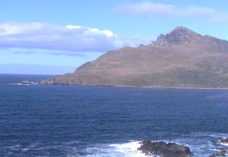
The real Cape Horn, seen from the Chilean Navy station location
The need for ships to round the horn was greatly reduced by the opening of the Panama Canal in 1914. However, sailing around the Horn is widely regarded as one of the major challenges in yachting, and a few recreational sailors continue to sail this route, sometimes as part of a circumnavigation of the globe, almost all of these choosing routes through the canals to the north of the actual Cape, though many take a detour through the islands and anchor to wait for fair weather to actually visit Horn Island or even sail around it to replicate a rounding of this historic point. Several prominent ocean yacht races, notably the Vendée Globe, sail around the world via the Horn, and speed records for round-the-world sailing follow the same route.
Geography
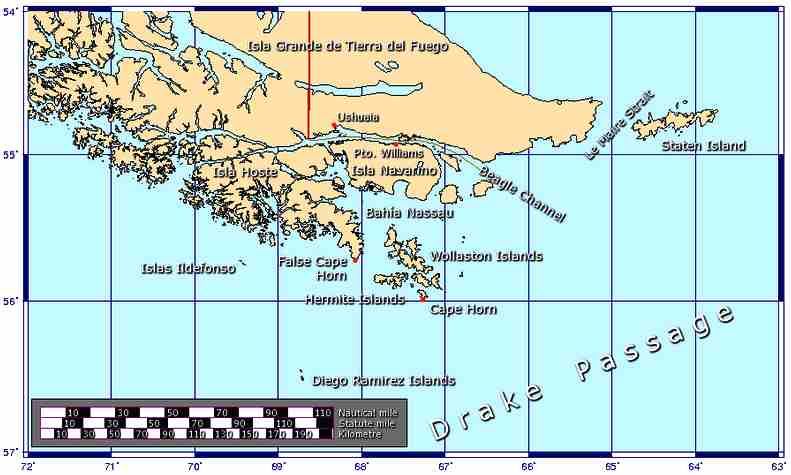
The southern part of South America, including Cape Horn island, the Drake Passage, and the South Shetland Islands.Cape Horn island is the southernmost point of land closely associated with South America; it is located at 55°59′00″S, 067°16′00″W, on Isla Hornos in the Hermite Islands group, at the southern end of the Tierra del Fuego
archipelago. It marks the north edge of the Drake Passage, the strait between South America and Antarctica. The dividing line between the Atlantic and Pacific oceans runs along the meridian of Cape Horn, from Tierra del Fuego to the Southern
Ocean. It is located in Cabo de Hornos National Park.
Cape Horn island was originally given the Dutch name "Kaap Hoorn", in honour of the Dutch city of Hoorn; in a typical example of false friends, the Hoorn became known in English as "Cape Horn", and in Spanish as "Cabo de Hornos" (which literally means "Cape of
Ovens") It is commonly known to sailors simply as The
Horn.
While Cape Horn is widely considered to be the southernmost point of South America, it is not actually the southernmost point of the South American continental landmass (the southernmost point of the continental landmass is Cape Froward on Brunswick Peninsula). Cape Horn is located on Isla Hornos, the most southerly of the Hermite Islands, which themselves are part of the Tierra del Fuego
archipelago. Tierra del Fuego is separated from the South America mainland by the Strait of Magellan. Also of note, the southernmost point of land on the South American continental shelf is on the Diego Ramirez Islands. On the other hand, 56 kilometers (35 mi) to the northwest from Cape Horn on Hoste Island lies False Cape Horn, which is so named because as sailors approaching from the west would confuse it with Cape Horn, and since the Wollaston Islands are due east of the false cape, this navigation error has led to several
shipwrecks.
The main building of the Chilean lighthouse station.The cape lies within Chilean territorial waters, and the Chilean Navy maintains a station on Hoorn Island, consisting of a residence, utility building, chapel, and
lighthouse; A short distance from the main station is a memorial, including a large sculpture featuring the silhouette of an albatross, in honour of the sailors who died while attempting to "round the
Horn".
However, the Chilean Navy station, including the lighthouse, and the memorial are not located in the Cape Horn itself, that is rather inaccessible both by land and by sea, but in another land point about a mile farther east-northeast. In the real Cape Horn there is a 4 m (13 ft) fiberglass light tower with a focal plane of 40 m (131 ft) and a range of about 21 km (13 mi)), which is the authentic Cape Horn lighthouse, but for unknown reasons it is not publicized as the end of the world light.
The terrain is entirely treeless, although quite lush owing to the frequent precipitation.
Cape Horn
Climate
The climate in the region is generally cool, owing to the southern latitude. There are no weather stations in the group of islands including Cape Horn; however, a study in 1882–1883 found an annual rainfall of 1,357 millimetres (53.42 in), with an average annual temperature of 5.2 °C (41.4 °F). Winds were reported to average 30 kilometres per hour (19 mph), with squalls of over 100 kilometres per hour (62 mph) occurring in all
seasons.
Contemporary weather records for Ushuaia, 146 kilometres (91 mi) north, show that summer (January–February) average temperatures range from highs of 14 °C (57 °F) to lows of 5 °C (42 °F); in winter (July), average temperatures range from 4 °C (40 °F) to −2 °C (29 °F). Cloud cover is generally high, with averages from 5.2 eighths in May and July to 6.4 eighths in December and
January. Precipitation is high throughout the year: the weather station on the nearby Diego Ramirez Islands, 109 kilometres (68 mi) south-west in the Drake Passage, shows the greatest rainfall in March, averaging 137.4 millimetres (5.41 in); while October, which has the least rainfall, still averages 93.7 millimetres (3.69
in). Wind conditions are generally severe, particularly in winter. In summer, the wind at Cape Horn is gale force up to 5% of the time, with generally good visibility; however, in winter, gale force winds occur up to 30% of the time, often with poor
visibility.
Many stories are told of hazardous journeys "around the Horn," most describing fierce storms. In sea chanteys and other songs, "Cape Horn" is frequently rhymed with "never been born."
Political
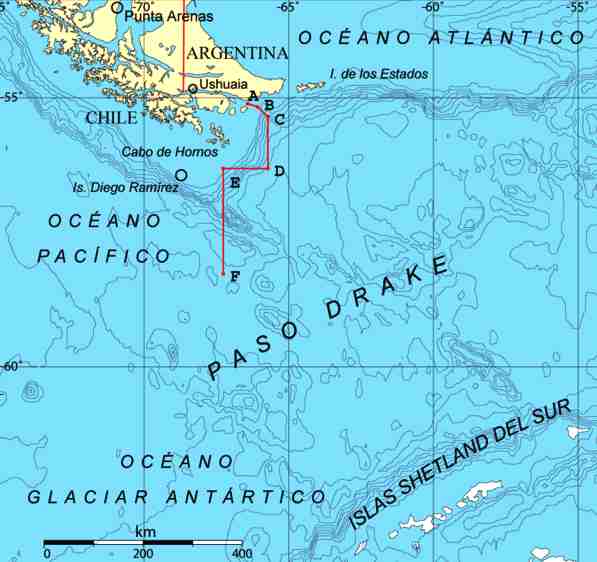
The islands around Cape Horn.Cape Horn is part of the Commune of Cabo de Hornos, whose capital is Puerto Williams; this in turn is part of Antártica Chilena Province, whose capital is also Puerto Williams. The area is part of the Magallanes y la Antártica Chilena Region of
Chile.
Puerto Toro, a few miles south of Puerto Williams, is the closest town to the cape, and the southernmost town in the world.
Sailing routes
There are a number of potential sailing routes around the tip of South America. The Strait of Magellan, between the mainland and Tierra del Fuego, is a major — although narrow — passage, which was in use for trade well before the Horn was discovered; the Beagle Channel, between Tierra del Fuego and Isla Navarino, offers a potential, though difficult route; and there are various passages around the Wollaston and Hermite Islands to the north of Cape
Horn.
All of these, however, are notorious for treacherous williwaw winds, which can strike a vessel with little or no
warning; given the narrowness of these routes, there is a significant risk of then being driven onto the rocks. The open waters of the Drake Passage, south of Cape Horn, provide by far the widest route, at about 650 kilometres (400 mi) wide; this passage offers ample sea room for maneuvering as winds change, and is the route used by most ships and sailboats, despite the possibility of extreme wave
conditions.
Shipping hazards
Several factors combine to make the passage around Cape Horn one of the most hazardous shipping routes in the world: the fierce sailing conditions prevalent in the Southern Ocean generally; the geography of the passage south of the Horn; and the extreme southern latitude of the Horn, at 56° south. (For comparison, Cape Agulhas at the southern tip of Africa is at 35° south; Stewart Island at the south end of New Zealand is 47° south.)
The prevailing winds in latitudes below 40° south can blow from west to east around the world almost uninterrupted by land, giving rise to the "roaring forties" and the even more wild "furious fifties" and "screaming sixties". These winds are hazardous enough in themselves that ships traveling east would tend to stay in the northern part of the forties (i.e. not far below 40° south latitude); however, rounding Cape Horn requires ships to press south to 56° south latitude, well into the zone of fiercest
winds.These winds are further exacerbated at the Horn by the funneling effect of the Andes and the Antarctic peninsula, which channel the winds into the relatively narrow Drake Passage.
The strong winds of the Southern Ocean give rise to correspondingly large waves; these waves can attain enormous size as they roll around the Southern Ocean, free of any interruption from land. At the Horn, however, these waves encounter an area of shallow water to the south of the Horn, which has the effect of making the waves shorter and steeper, greatly increasing the hazard to ships. If the strong eastward current through the Drake Passage encounters an opposing east wind, this can have the effect of further building up the
waves. In addition to these "normal" waves, the area west of the Horn is particularly notorious for rogue waves, which can attain heights of up to 30 metres (100
ft).
The prevailing winds and currents create particular problems for vessels attempting to round the Horn against them, i.e. from east to west. Although this affects all vessels to some extent, it was a particularly serious problem for traditional sailing ships, which could make very little headway against the wind at the best of
times; modern sailing boats are significantly more efficient to windward and can more reliably make a westward passage of the Horn, as they do in the Global Challenge race. In recent times, only two small yachts have taken this route, John Kershmere did so on his 32 footer in the early 80s. Lin and Larry Pardey sailed west around the Cape in 2003 on an engineless 29 footer.
Finally, ice is a hazard to sailors venturing far below 40° south. Although the ice limit dips south around the horn, icebergs are a significant hazard for vessels in the area. In the South Pacific in February (summer in Southern Hemisphere), icebergs are generally confined to below 50° south; but in August the iceberg hazard can extend north of 40° south. Even in February, though, the Horn is well below the latitude of the iceberg
limit. These hazards have made the Horn notorious as perhaps the most dangerous ship passage in the world; many ships were wrecked, and many sailors died, attempting to round the Cape.
History
Discovery
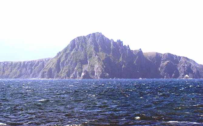
Approaching Cape Horn from the south-west.In 1525 the vessel San Lesmes commanded by Francisco de Hoces, member of the Loaísa Expedition, was blown south by a gale in front of the Atlantic end of Magellan Strait and reached 56º S where they thought to see Land's End.
In September 1578, Sir Francis Drake, in the course of his circumnavigation of the world, passed through the Strait of Magellan into the Pacific Ocean. Before he could continue his voyage north his ships encountered a storm, and were blown well to the south of Tierra del Fuego. The expanse of open water they encountered led Drake to guess that far from being another continent, as previously believed, Tierra del Fuego was an island with open sea to its south. This discovery went unused for some time, as ships continued to use the known passage through the Strait of
Magellan.
By the early 1600s, the VOC held a monopoly on all Dutch trade via the Strait of Magellan and the Cape of Good Hope, the only two known routes at the time to the Far East. In an effort to find an alternative route and hence break the monopoly, the Dutch merchant Jacob le Maire, together with navigator Willem Schouten, set off to investigate Drake's suggestion of a route to the south of Tierra del Fuego. Backed by the city leaders of the Dutch town of Hoorn, the expedition set off in two ships, Eendracht and Hoorn, in May, 1615.
Hoorn was accidentally destroyed in Patagonia, but in January, 1616, Eendracht passed through the Le Maire Strait, as it is now known, and sighted a high island to the south. They named the new cape "Kaap Hoorn", in honour of the expedition's
sponsors. At the time it was discovered, the Horn was believed to be the southernmost point of Tierra del Fuego; the unpredictable violence of weather and sea conditions in the Drake Passage made exploration difficult, and it was only in 1624 that the Horn was discovered to be an island. It is an interesting testament to the difficulty of conditions there that Antarctica, only 650 kilometres (400 mi) away across the Drake Passage, was discovered as recently as 1820, despite the passage having been used as a major shipping route for 200
years.
Trade route
The clipper route followed by ships sailing between England and Australia/New Zealand passed around Cape Horn.From the 1700s to the early 1900s, Cape Horn was a part of the clipper routes which carried much of the world's trade. Clipper ships sailed round the horn carrying wool, grain, and gold from Australia back to
Europe; much trade was carried around the Horn between Europe and the Far East; and trade and passenger ships travelled between the coasts of the United States via the
Horn. The Horn exacted a heavy toll from shipping, however, owing to the extremely hazardous combination of conditions there.
Traditionally, a sailor who had rounded the Horn was entitled to wear a gold loop earring — in the left ear, the one which had faced the Horn in a typical eastbound passage — and to dine with one foot on the table; a sailor who had also rounded the Cape of Good Hope could place both feet on the
table. A sailor who had sailed around Cape Horn was also able to brag by showing off his tattoo of a full-rigged ship.
The transcontinental railroads in North America, as well as the Panama Canal in Central America, led to the gradual decrease in use of the Horn for trade. As steamships replaced sailing ships, Pamir became the last commercial sailing ship to round Cape Horn laden with cargo, en route from Australia to Finland in 1949.
Recreational and sport sailing
Despite the opening of the Suez and Panama Canals, the Horn remains part of the fastest sailing route around the world, and so the growth in recreational long-distance sailing has brought about a revival of sailing via the Horn. Owing to the remoteness of the location and the hazards there, a rounding of Cape Horn is widely considered to be the yachting equivalent of climbing Mount Everest, and so many sailors seek it out for its own
sake.
The first small boat to sail around Cape Horn was the 42-foot (13 m) yacht Saoirse, sailed by Conor O'Brien with three friends, who rounded it during a circumnavigation of the world between 1923 and
1925. In 1934, the Norwegian Al Hansen was the first to round Cape Horn single-handed from east to west — the "wrong way" — in his boat Mary Jane, but was subsequently wrecked on the coast of
Chile. The first person to successfully circumnavigate the world single-handed via Cape Horn was Vito Dumas, who made the voyage in 1942 in his 33-foot (10 m) ketch Lehg II; a number of other sailors have since followed
him. including Webb Chiles aboard "EGREGIOUS" who in December 1975 became the first American to round Cape Horn single-handed.
Today, there are several major yacht races held regularly along the old clipper route via Cape Horn. The first of these was the Sunday Times Golden Globe Race, which was a single-handed race; this inspired the present-day Around Alone race, which circumnavigates with stops, and the Vendée Globe, which is non-stop. Both of these are single-handed races, and are held every four years. The Volvo Ocean Race is a crewed race with stops which sails the clipper route every four years. The Jules Verne Trophy is a prize for the fastest circumnavigation of the world by any type of yacht, with no restrictions on the size of the crew (no assistance, non-stop). Finally, the Global Challenge race goes around the world the "wrong way", from east to west, which involves rounding Cape Horn against the prevailing winds and currents.
The Horn remains a major hazard for recreational sailors, however. A classic case is that of Miles and Beryl Smeeton, who attempted to round the Horn in their yacht Tzu Hang. Hit by a rogue wave when approaching the Horn, the boat pitchpoled (ie. somersaulted end-over-end). Although they survived, and were able to make repairs in Talcahuano, Chile, they attempted the passage again, only to be rolled over, and dismasted for a second time, by another rogue wave, which again they miraculously
survived.
Literature and culture
Cape Horn has been an icon of sailing culture for centuries; it has featured in sea
shanties and in many books about sailing. One of the classic accounts of a working ship in the age of sail is Two Years Before the Mast, by Richard Henry Dana, Jr., in which the author describes an arduous trip from Boston to California via Cape Horn:
“ Just before eight o'clock (then about sundown, in that latitude) the cry of "All hands ahoy!" was sounded down the fore scuttle and the after hatchway, and hurrying upon deck, we found a large black cloud rolling on toward us from the south-west, and blackening the whole heavens. "Here comes Cape Horn!" said the chief mate; and we had hardly time to haul down and clew up, before it was upon us. In a few moments, a heavier sea was raised than I had ever seen before, and as it was directly ahead, the little brig, which was no better than a bathing machine, plunged into it, and all the forward part of her was under water; the sea pouring in through the bow-ports and hawse-hole and over the knightheads, threatening to wash everything overboard. In the lee scuppers it was up to a man's waist. We sprang aloft and double reefed the topsails, and furled all the other sails, and made all snug. But this would not do; the brig was laboring and straining against the head sea, and the gale was growing worse and worse. At the same time sleet and hail were driving with all fury against us. We clewed down, and hauled out the reef-tackles again, and close-reefed the fore-topsail, and furled the main, and hove her to on the starboard tack. Here was an end to our fine
prospects. ”
Charles Darwin, in The Voyage of the Beagle, a journal of the five-year expedition upon which he based The Origin of Species, described his 1832 encounter with the Horn:
“ ... we closed in with the Barnevelts, and running past Cape Deceit with its stony peaks, about three o'clock doubled the weather-beaten Cape Horn. The evening was calm and bright, and we enjoyed a fine view of the surrounding isles. Cape Horn, however, demanded his tribute, and before night sent us a gale of wind directly in our teeth. We stood out to sea, and on the second day again made the land, when we saw on our weather-bow this notorious promontory in its proper form — veiled in a mist, and its dim outline surrounded by a storm of wind and water. Great black clouds were rolling across the heavens, and squalls of rain, with hail, swept by us with such extreme violence, that the Captain determined to run into Wigwam Cove. This is a snug little harbour, not far from Cape Horn; and here, at Christmas-eve, we anchored in smooth
water. ”
Alan Villiers, a modern-day expert in traditional sailing ships, wrote many books about traditional sailing, including By way of Cape
Horn. More recent sailors have taken on the Horn singly, such as Vito Dumas, who wrote Alone Through The Roaring Forties based on his round-the-world
voyage; or with small crews.
Bernard Moitessier made two significant voyages round the horn; once with his wife Françoise, described in Cape Horn: The Logical
Route, and once single-handed. His book The Long Way tells the story of this latter voyage, and of a peaceful night-time passage of the Horn: "The little cloud underneath the moon has moved to the right. I look... there it is, so close, less than 10 miles away and right under the moon. And nothing remains but the sky and the moon playing with the Horn. I look. I can hardly believe it. So small and so huge. A hillock, pale and tender in the moonlight; a colossal rock, hard as
diamond."}}
And John Masefield wrote: "Cape Horn, that tramples beauty into wreck / And crumples steel and smites the strong man
dumb"
'Rounding the Horn'
Visiting Cabos de Hornos can be done on a day trip by helicopter or more arduously by charter power boat or sailboat. However, "rounding the Horn" is traditionally understood to involve sailing from 40 South on one coast to 40 South on the other coast, a considerably more difficult and time-consuming endeavor.
Cape Horn, Chile, Argentina - Sir Francis
Drakes's Passage
LINKS
and REFERENCE
-
Cape
Horn the Terrible, by
Paolo Venanzangeli; from Nautical Web.
-
Cabo
de Hornos, by Mariolina Rolfo and Giorgio Ardrizzi. From Patagonia
and Tierra del Fuego Nautical Guide, Editrice Incontri Nautici,
2004. ISBN 88-85986-34-X
-
Limits
of Oceans and Seas. International Hydrographic Organization
Special Publication No. 23, 1953.
-
Perilous
Cape Horn, by P.J. Gladnick; from eSsortment, 2002.
-
Journeys
in Time: Places, from Macquarie University Library, 2004.
-
Cape
Horn, from Victory Cruises, 2005.
-
Isla
Hornos Lighthouse, from Lighthouse Depot.
-
Cape
Horn Memorial, by Roberto Benavente; from Fundacion
Caphorniers Chile.
-
Opiliones
from the Cape Horn Archipelago, James C. Cokendolpher and
Dolly Lanfranco L.; from Texas Tech University, 1985
-
Ushuaia:
Monthly Normals, from Weather Underground.
-
Isla
Diego Ramirez: Monthly Normals, from Weather Underground.
-
U.S.
Navy Marine Climatic Atlas of the World: Rounding Cape Horn,
1995.
-
(Spanish)
Cabo
de Hornos designado Reserva de la Biósfera, from CONAF.
-
Sailing
the Patagonian channels, from Yachting Club CERN, 2005.
-
Winds
of the World: The Williwaw, from Weather Online.
-
Rogue
waves, from Europa Research.
-
Voyage
of the Golden Hind, from The Golden Hind.
-
The
Circumnavigators, by Don Holm; Around the Three Capes.
Prentice-Hall, NY, 1974.
-
North
America and the Cape Horn Route, by Captain Harold D. Huycke;
from Caphorniers Chile.
-
Covey
Crump — "cape", Commander A. Covey-Crump, RN,
1955; from the Royal Navy.
-
'Vanishing
Tattoo'
-
Rob
Duncan's Quest for Cape Horn, by Rob Duncan.
-
The
Modern Cape Horner, from Victory Expeditions.
-
Cape
Horn to Starboard, from Lin and Larry Pardey.
-
The
Circumnavigators, by Don Holm; Chapter 15.
-
List
Of Solo Circumnavigators, from the Joshua Slocum Society
International.
-
Around
Cape Horn, from Frank Petersohn.
-
Two
Years Before the Mast: A Personal Narrative, by Richard Henry
Dana; Chapter V, Cape Horn — A Visit. Signet Classics, 2000.
ISBN 0-451-52759-3
-
The
Voyage of the Beagle, by Charles Darwin. National Geographic,
2004. ISBN 0-7922-6559-9.
Cape
Horn
|
Adelaide
Aden
- Yemen
Afghanistan
Africa
Alaska
Algeria
Amsterdam
Antarctic
- Antarctica
Arctic
- North
Pole
Argentina
Asia
Athens
Atlantis
- Plato's Lost City
Australia
Austria
Aztecs
- Mexico
Bahamas
Bangladesh
Baghdad
Bahrain
Barbados
Beachy
Head, England
Belgium
Berlin
Bermuda
Black
Rock Desert, Nevada
Bohemia
Bolivia
Bonneville,
Utah - History
Brazil
Brighton
- West Pier
British
Columbia
Bulgaria
Burma
Canada
Canary
Islands
Cape
York - Au
Caribbean
- Central America
Cayman
Islands
Chichester
Harbour
Chile
China
- Beijing
Columbia
- S. America
Columbo
- Sri Lanka
Cowes,
Isle of Wight
Croatia
Cuba
Cyprus
Czechoslovakia
Darwin
- Australia
Daytona
Beach - Florida USA
Denmark
Dubai
Eastbounre
Pier, England
Earthquakes
Egypt
Equador
Equator
Europe
Falkland
Islands
Falmouth,
Cornwall
Fiji
Finland
Florida
France
Galapagos
Islands
Geography
Links
Geography
Records
Geography
Resources
|
Geography
Statistics
Germany
Gibraltar
- Links
Greece
Greenland
Hampshire
Hawaii
Holland
- Volendam
Hollywood,
California, LA
Hong
Kong
Hungary
Hurricanes
Iceland
India
- Mumbai
Indonesia
Links
Iran
Iraq
Ireland
Isle
of Man
Isle
of Wight - The
Needles
Israel
Italy
Jakarta
- Java
Jamaica
Japan
Jordan
Kent,
England - Sandgate
Kenya
Korea
Kuwait
Kyoto
- Japan
Las
Vegas -
Lebanon
Libya
Life
on Earth
London
- Big
Ben
London
Eye - Madame
Tussauds
London
Houses
Parliament
London
- Buckingham
Palace
London
- Old
Bailey
London
- Overview
London
- The City
London
- Tower Bridge
London
- Trafalgar
Square
Luxembourg
Malaysia
Malta
Maya
Empire -
Central America
Melbourne,
Australia
Mexico
Middle
East
Monaco
Morocco
Mountains
Naples-
Italy
National
Geographic
Nepal
Nertherlands
- Eindhoven
New
York
New
Zealand
Nigeria
North
Africa
Norway
Nova
Scotia
Oceans
and Seas
Oman
Pakistan
Palermo
- Sicily
Palestine
|
Palma
- Malorca
Panama
Canal - Links
Paris
Pendine
Sands - Carmarthen
Peru
Philippines
Pisa
Planet
Earth
Poland
Port
Moresby - PNG
Port
Said - Egypt
Portugal
Puerto
Rico
Qatar
Quebec
Rio
de Janeiro
Romania
Rome
Russia
Salt
Lake City - Utah
Saudi
Arabia
Scotland
Senegal
West Africa
Singapore
Somalia
South
Africa
South
America
Southampton
Spain
- Espana
Sri
Lanka - Links
Stonehenge
Suez
Canal
Sudan
Surrey,
England Index
Sussex,
England Index
Sweden
Switzerland
Sydney,
Australia
Syria
Tahiti
- Polynesia -
Links
Taiwan
Thailand
Tokyo,
Japan
Tonga
- Polynesia
Toronto
Trinidad
- Lesser Antilles
Tsunami
Tunbridge
Wells, England
Tunisia
Turkey
UAE
- United Arab Emirates
UK
Statistics
Ukraine
United
Kingdom
United
Kingdom - Gov
USA
Venezuela
Venice
Vienna
Vietnam
Volcanoes
Wales
Washington
D.C.
Wealden
iron industry
Wendover,
Utah
World
Peace Supporters
Yemen
Yugoslavia
Zurich
|

Solar
Cola drinkers care about planet
earth
..
Thirst for Life

(330ml
Planet Earth
can)
|