|
COLUMBIA
|
|||||||||||||||||||||||||||||||||||||||||||||||||||||||||||||||||
|
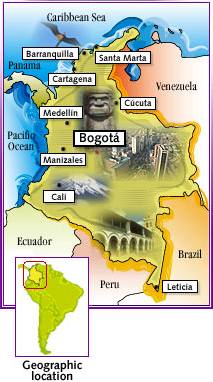
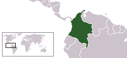
The Republic of Colombia (Spanish: República de Colombia), is a country in northwestern South America. It's bordered to the east by Venezuela and Brazil, to the south by Ecuador and Peru, to the North by the Atlantic Ocean and to the west by Panama and the Pacific Ocean.
Origin and history of the name
Colombia's name references the explorer Christopher Columbus. The name was conceived by the revolutionary Francisco de Miranda as a reference to the New World, especially to all American territories and colonies under Spanish and Portuguese rule. The name originally belonged to a short-lived republic consisting of present-day Colombia, Venezuela, Ecuador, and Panama. This republic collapsed in 1830 when Venezuela and Ecuador separated, and the Cundinamarca region which remained became a new country, the Republic of New Granada. In 1863 New Granada changed its name officially to United States of Colombia, and in 1886 adopted its present day name: Republic of Colombia.
History
About 10450 BC there was cultural activity near Bogotá, in "El Abra". In 10000 BC, groups of Amerindians developed the political system of "cacicazgos" (answering to a figure known as the Cacique) with a pyramidal structure of power, especially in the cases of the Muisca people. They have been considered to have one of the most developed political systems in South America, after the Incas. Spanish explorers made the first exploration of the Caribbean littoral in 1500 led by Rodrigo de Bastidas. Christopher Columbus navigated near the Caribbean in 1502. In 1508 Vasco Nuñez de Balboa started the conquest of the territory through the region of Urabá. In 1513, he was also the first European to discover the Pacific Ocean which he called Mar del Sur (or "Sea of the South") and which in fact would bring the Spaniards to Peru and Chile. In 1525, the first European city in the American Continent was founded, Santa María la Antigua del Darién in what is today the Chocó Department. The territory's main population was made up of hundreds of tribes of the Chibchan and "Karib", currently known as the Caribbean people, whom the Spaniards conquered through warfare, while resulting disease, exploitation, and the conquest itself caused a tremendous demographic reduction among the indigenous. In the 16th century, Europeans began to bring slaves from Africa.
Since the beginning of the periods of Conquest and Colonization, there were several rebel movements under Spanish rule, most of them either being crushed or remaining too weak to change the overall situation. The last one, which sought outright independence from Spain, sprang up around 1810. Eventually being led by Simón Bolívar and Francisco de Paula Santander, the rebellion finally succeeded in 1819, when the territory of the Viceroyalty of New Granada became the Republic of Great Colombia, as a Confederation with Ecuador and Venezuela. Modern day Panama, which subsequently remained a Colombian department until 1903, when it became independent, was also included in this union
Internal political and territorial divisions led to the secession of Venezuela and Quito (today's Ecuador) in 1830. At this time, the so-called "Department of Cundinamarca" adopted then the name "Nueva Granada", which it kept until 1856 when it became the "Confederación Granadina" (Grenadine Confederation). In 1863 the "United States of Colombia" was created, lasting until 1886, when the country finally became known as the Republic of Colombia. Internal divisions remained, occasionally igniting very bloody civil wars and, eventually, contributing to setting the stage for the U.S.-sponsored secession of Panama in 1903. Afterwards, the country achieved a relative degree of political stability, which was interrupted by a bloody conflict which took place between the late 1940s and the early 1950s, known as La Violencia ("The Violence"). Its cause was mainly due to mounting tensions between partisan groups, reignited by the murder of Jorge Eliécer Gaitán, and it claimed the lives of at least 180,000 Colombians.
Alvaro Uribe Vélez, President of Colombia
To replace the previous 1886 document, a new constitution was made in 1991, after being drafted by the Constituent Assembly of Colombia. The constitution included key provisions on political, ethnic, human and gender rights, which have been gradually put in practice, though uneven developments, surrounding controversies, and setbacks have persisted.
In recent decades the country has been plagued by the effects of the influential drug trade and by guerrilla insurgents such as the Fuerzas Armadas Revolucionarias de Colombia (Revolutionary Armed Forces of Colombia), or FARC, and illegal counter-insurgency paramilitary groups such as the Autodefensas Unidas de Colombia (United Self-Defense Forces of Colombia), or AUC, which along with other minor factions have been engaged in a bloody internal armed conflict.
The powerful drug cartels have helped the Colombian balance of trade by creating a steady and substantial influx of foreign currency, mainly U. S. dollars. On the other hand, the druglords have destabilized the government and, in the 1980s, the neighbour country of Panama which was invaded by the United States in 1989 to remove strongman General Manuel Noriega because of his alleged links to the drug trade. The different insurgent irregular groups often resort to kidnapping and drug smuggling to fund their causes, tend to operate in large areas of the remote rural countryside and can sometimes disrupt communications and travel between different regions. Since the early 1980s, attempts at reaching a negotiated settlement between the government and the different rebel groups have been made, either failing or achieving only the partial demobilization of some of the parties involved. One of the last such attempts was made during the administration of President Andrés Pastrana Arango, which negotiated with the FARC between 1998 and 2002.
In the late 1990s, President Andrés Pastrana implemented an initiative named Plan Colombia, with the dual goal of ending the armed conflict and promoting a strong anti-narcotic strategy. The most controversial element of the Plan, which also included a smaller number of funds for institutional and alternative development, was considered to be its anti-narcotic strategy, consisting on an increase in aerial fumigations to eradicate coca. This activity came under fire from several sectors, which claimed that fumigation also damages legal crops and has adverse health effects upon population exposed to the herbicides. Critics of the initiative also claim that the plan represents a military approach to problems that have additional roots in the social inequalities of the country.
During the presidency of Alvaro Uribe, who was elected on the promise to apply military pressure on the FARC and other criminal groups, some security indicators have improved, showing a decrease in reported kidnappings (from 3700 in the year 2000 to 1441 in 2004) and a decrease of more than 48% in homicides between July 2002 and May 2005. It is argued that these improvements have favored economic growth. [1]
Analysts and critics inside Colombia agree that there has been a degree of practical improvement in several of the mentioned fields, but the exact reasons for the figures themselves have sometimes been disputed, as well as their specific accuracy. Some opposition sectors have criticized the government's security strategy, claiming that it is not enough to solve Colombia's complex problems and that it has contributed to creating a favorable environment for the continuation of some human rights abuses.
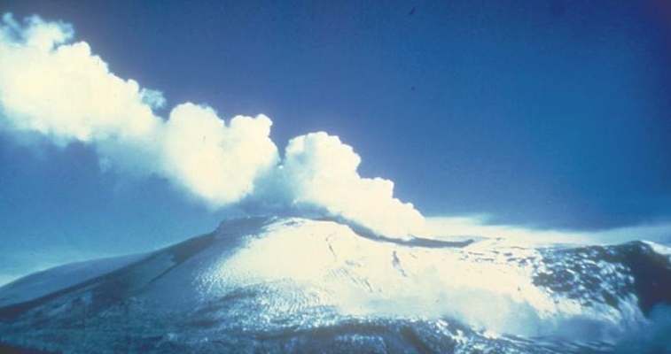
Nevado del Ruiz
Politics
Colombian Constitution of 1991
Executive Branch: Colombia is a republic where the executive branch dominates government structure. Up until recently, the president was elected together with the vice-president by popular vote for a single four-year term, which functioned as both head of government and head of state. However, on October 19, 2005, the Colombian Congress amended the constitution, which now allows Colombian presidents to serve up to two consecutive four-year terms. However department governors, mayors of cities and towns and other executive branch officials are only elected for a three year term, and cannot be reelected.
On May 28, 2006, president Álvaro Uribe Vélez was reelected by a vote of 62%, against 22% for Carlos Gaviria Díaz of the Democratic Pole, and 12% for Horacio Serpa Uribe of the Liberal Party.
Legislative branch: Colombia's bicameral parliament is the Congress of Colombia or Congreso, which consists of the 166-seat House of Representatives of Colombia and the 102-seat Senate of Colombia. Members of both houses are elected by popular vote to serve four-year terms. Colombia is also a member of the South American Community of Nations. With congressmen, Colombia also elects Department deputies, and city councils.
Judicial Branch: In the 1990s, the Colombian judicial system underwent significant reforms and is undergoing a process of migration from an inquisitorial system to an adversarial system. Parts of the coffee growing region of Colombia and Bogotá have already adopted the adversarial system, with the rest of the country following suit starting on January 1, 2006. The judicial system is headed by a Supreme Justice Court and members are appointed by the president and congress.
Geography
Colombia is located in the north of South America (4°N, 72°W) and is part of Caribbean South America. It has sea borders with Jamaica, Haiti and the Dominican Republic to the east and Costa Rica and Guatemala to both east and west; and land borders with Panama (225 km/140 mi) to the northwest, Ecuador (590 km/367 mi) and Peru (1,496 km/930 mi) to the south, Brazil (1,643 km/1,021 mi) to the southeast, and Venezuela (2,050 km/1,274 mi) to the east. Colombia is the only South American country to have coastlines on both the Atlantic Ocean (1,760 km/1,094 mi) and the Pacific Ocean (1,448 km/900 mi).
Colombia has a total area of 1,138,910 square kilometres (439,736 sq. mi) being the fourth biggest country in South America after Brazil, Argentina and Peru and the seventh largest one in the the Americas. From this area, the land has 1,038,700 square kilometers (401,044 sq. mi) and the water area has 100,210 square kilometers (38,691 sq. mi). It has also an archipelago in the Caribbean sea (San Andres, Providencia and Santa Catalina) that forms the territory of the department San Andrés y Providencia.
The mainland is divided into four major geographic regions: Andean highlands (composed of three mountain ranges and intervening valley lowlands); Caribbean lowlands; Pacific lowlands; and Ilanos and tropical rainforest of eastern Colombia. Colombia also possesses small islands in both the Caribbean Sea and Pacific Ocean.
A striking variety in temperature results primarily from differences in elevation, but there is little seasonal variation. Habitable areas consist of hot (below 900 m / 2,950 ft in elevation), temperate (between 900 & 1,980 m or 2,950 & 6,500 ft), and cold (from 1,980 m to about 3,500 m or from 2,950 ft to 11,500 ft) climatic zones. Precipitation generally moderate to heavy, with highest levels in Pacific lowlands and in parts of eastern Colombia; considerable year-to-year variations recorded.
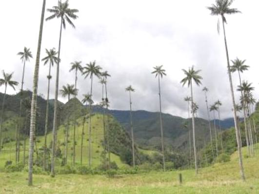
Cocora's Valley
The Andes range is located in Colombia from Southwest (Ecuador boarder) toward Northeast (Venezuela boarder) and is divided in the Colombian Massif (Macizo Colombiano) in three ranges (East Range, Centre Range and West Range) that form two long valleys, Magdalena and Cauca follow by the rivers of the same name. The highest mountain in Colombia is not in the Andes but in the Caribbean plain: Sierra Nevada de Santa Marta with its highest points named Pico Cristobal Colon (5,775 m or 18,947 ft) and Pico Simon Bolivar (same elevation).
The eastern part of Colombia, comprising more than half its territory, is plain and composed by savanna and rainforest, crossed by rivers belonging to the Amazon and Orinoco basins. The northern part, called "Los Llanos" is a savanna region, mostly in the Orinoco basin (therefore called also Orinoquía). The southern part, usually called Amazonía, is covered by the Amazon rain forest and belongs mostly to the Amazon basin.
At the north and west of the Andes there are coastal plains, the Caribbean plains to the north and the Pacific plains to the west.
The five traditional natural regions are therefore: the Andean Region, the Caribbean Region, the Pacific Region, the Orinoquia Region and the Amazonia Region. Some people also include an Insular Region, separated from the coastal regions.
Administrative divisions
Colombia is divided into 32 departments (departamentos) and one capital district (distrito capital). The departments (with capital city in parentheses) include:
Colombia is subdivided into municipalities (municipios), which are further subdivided into corregimientos.
Cities of Colombia
Colombia has many significant cities. 21 of them, with their nicknames, are listed here:
Bogotá (La Atenas Suramericana – South America's Athens), Medellín (La ciudad de la eterna primavera – The City Of Eternal Spring), Cali (La sucursal del cielo – Heaven's Branch), Barranquilla (La puerta de oro de colombia – Colombia's Golden Gate), Bucaramanga (La ciudad de los parques – The City of Parks), Cartagena (La heroica – The Heroic (City)), Pereira (La querendona, trasnochadora y morena – The Lovely Sleepless Brunette), Manizales (La ciudad de las puertas abiertas – The City Of Open Gates), Cúcuta (La hermosa villa - The Beautiful Village), Pasto (Ciudad Sorpresa – The Surprise City), Armenia (La Ciudad Milagro – The Miracle City), Villavicencio (La Puerta al Llano - The Llano's Gate), Valledupar (Capital mundial del vallenato – World's Vallenato Capital), Ibagué (Capital Músical de Colombia - Colombia's Music Capital), Popayán (La Ciudad Blanca - The White City), Sincelejo (La ciudad de las corralejas - The city of the "bullruns"), Santa Marta (La perla de oro - The golden pearl), Tunja (La capital del haba, el tejo y la ruana), Neiva (Neivayork), Montería (La capital ganadera de Colombia - The colombian cattle capital), Quibdó (La perla negra - The black pearl).
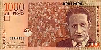
Colombian 1.000 peso bill front
Economy
After experiencing decades of steady growth (average GDP growth exceeded 4% in the 1970-1998 period), Colombia experienced a recession in 1999 (the first full year of negative growth since 1929), and the recovery from that recession was long and painful. Colombia's economy suffers from weak domestic and foreign demand, austere government budgets, and serious internal armed conflicts. The IMF Economic Indicators published on September 21, 2005, forecast the Colombian GDP to reach US$112,300,000,000 in 2005. Inflation has been below 6% for 2004 and 2005, and is expected to remain below 5% during 2006. Colombia's main exports include manufactured goods (41.32% of exports), petroleum (28.28%), coal (13.17%), and coffee (6.25%). All imports, exports, and the general trade balance are in record levels, and the inflow of export dollars has resulted in substantial revaluation of the Colombian peso.
The problems facing the country range from pension system problems to drug dealing to high unemployment. Several international financial institutions have praised the economic reforms introduced by current President Alvaro Uribe, which include measures designed to bring the public-sector deficit below 2.5% of gross domestic product (GDP). The government's economic policy and its controversial democratic security strategy have engendered a growing sense of confidence in the economy, and GDP growth in 2003 was among the highest in Latin America.
Demographics
With over 41 million people, Colombia is the third-most populous country in Latin America, after Brazil and Mexico. It also has the third largest Black/African-descent population in the western hemisphere after Brazil and the US. Movement from rural to urban areas was very heavy in the middle of the 20th century, but has since tapered off. The urban population increased from 31% of the total population in 1938, to 57% in 1951 and about 70% by 1990. Currently the figure is about 77%. Thirty cities have a population of 100,000 or more. The nine eastern lowlands departments, constituting about 54% of Colombia's area, have less than 3% of the population and a density of less than one person per square kilometer (two persons per sq. mi.).
The country has a diverse population that reflects its colourful history and the peoples that have populated here from ancient times to the present. The historic amalgam of three main groups are the basics of Colombia's current demographics: indigenous Amerindians, European immigrants, and African slaves. Many of the indigenous peoples were absorbed into the mestizo population, but the remaining 700,000 currently represent over 85 distinct cultures. The European immigrants were primarily Spanish colonists, but a small number of other Europeans (Italian, German, French, Swiss and in smaller numbers Belgian, Lithuanian, Dutch, English and Croatian communities) immigrated during the Second World War and the Cold War. For example, former Bogota mayor Antanas Mockus is the son of Lithuanian immigrants. The Africans were brought as slaves, mostly to the coastal lowlands, beginning early in the 16th century, and continuing into the 19th century. After abolition, a national ideology of mestizaje encouraged the mixing of the indigenous and Afro-Colombian communities into a single mestizo ethnic identity [2].
Other smaller immigrant populations include Asians and Middle Easterners, particularly Arabs, Chinese, and Japanese.
As of 2006, Colombia has about 3 million internally displaced persons, the highest number of any country in the western hemisphere, and second worldwide, after Sudan.
Religion
87% of the population practices Roman Catholicism. Another 9% is divided mainly amongst the Protestant, Mormon, Jewish and Muslim religions. 3% of the population declares itself to be Non Religious. 1% of Colombians practice indigenous religions.
Solar Cola drinkers care about planet earth
.. Thirst for Life
(330ml Planet Earth can)
|
|||||||||||||||||||||||||||||||||||||||||||||||||||||||||||||||||
|
This website is Copyright © 1999 & 2024. The bird logo and name Solar Navigator are trademarks. All rights reserved. All other trademarks are hereby acknowledged. Max Energy Limited is an educational charity.
|
|||||||||||||||||||||||||||||||||||||||||||||||||||||||||||||||||