|
The Republic of Ghana is a country in West Africa. It borders Côte d'Ivoire (also known as Ivory Coast) to the west, Burkina Faso to the north, Togo to the east, and the
Gulf of Guinea to the south. The word "Ghana" means "Warrior
King", and was the source of the name "Guinea" (via French
Guinoye) used to refer to the West African coast (as in Gulf of Guinea).
Ghana was inhabited in pre-colonial times by a number of ancient kingdoms, including the Ga Adangbes on the eastern coast, inland Empire of Ashanti and various Fante states along the coast and inland. Trade with European states flourished after contact with the Portuguese in the 15th century, and the British established a crown colony, Gold Coast, in
1874.
Upon achieving independence from the United Kingdom in
1957, the name Ghana was chosen for the new nation to reflect the ancient Empire of Ghana that once extended throughout much of western Africa. In the Ashanti language it is spelled
Gaana.
History
Medieval Ghana (4th - 13th Century):The Republic of Ghana is named after the medieval Ghana Empire of West Africa. The actual name of the Empire was Ouagadougou. Ghana was the title of the kings who ruled the kingdom. It was controlled by Sundiata in 1240 AD, and absorbed into the larger Mali Empire. (Mali Empire reached its peak of success under Mansa Musa around 1307.) Around 1235 a Muslim leader named Sundiata united warring tribes. He then brought neighboring states under his rule to create the Mali empire.Its capital city was called Kumbi-Saleh.
Map of Ghana
Geographically, the old Ghana was approximately 500 miles (800 km) north of the present Ghana, and occupied the area between Rivers Senegal and Nigeria. Some inhabitants of present Ghana have ancestors linked with the medieval Ghana. This can be traced down to the Mande and Voltaic people of Northern
Ghana - Mamprussi, Dagomba and the Gonja. Anecdotal evidence connected the Akans to this Empire. The evidence lies in names like Danso shared by the Akans of present Ghana and Mandikas of Senegal/Gambia who have strong links with the Empire. Ghana was also the site of the Empire of Ashanti which was perhaps the most advanced black state in sub-Sahara Africa. It is said that at its peak, the King of Ashanti could field 500,000 troops.
Up until March 1957, Ghana was known to much of the world as the Gold Coast. The Portuguese who came to Ghana in the 15th Century found so much gold between the rivers Ankobra and the Volta that they named the place Mina - meaning Mine. The Gold Coast was later adopted by English colonists. The French, impressed with the trinkets worn by the coastal people, named the area to the west "Cote d'Ivoire," or Ivory Coast.
Elmina CastleIn 1481, King John II of Portugal commissioned Diogo d'Azambuja to build Elmina Castle, which was completed the next year. Their aim was to trade in gold, ivory and slaves, consolidating their burgeoning power in the region.
By 1598 the Dutch had joined them, and built forts at Komenda and Kormantsi. In 1637 they captured Elmina Castle from the Portuguese and Axim in 1642 (Fort St Anthony). Other European traders joined in by the mid 17th century, largely English, Danes and Swedes. The coastline was dotted by more than 30 forts and castles built by Dutch, British and Danish merchants. The Gold Coast became the highest concentration of European military architecture outside of Europe. By the latter part of 19th century the Dutch and the British were the only traders left and after the Dutch withdrew in 1874, Britain made the Gold Coast a protectorate.
For most of central sub-Saharan Africa, agricultural expansion marked the period before 500. Farming began earliest on the southern tips of the Sahara, eventually giving rise to village settlements. Toward the end of the classical era, larger regional kingdoms had formed in West Africa, one of which was the Kingdom of Ghana, north of what is today the nation of Ghana. After its fall at the beginning of the 13th century, Akan migrants moved southward then founded several nation-states including the first great Akan empire of the Bono which is now known as the Brong Ahafo region in Ghana. Later Akan groups such as the Ashanti federation and Fante states are thought to possibly have roots in the original Bono settlement at Bono manso. Much of the area was united under the Empire of Ashanti by the 16th century. The Ashanti government operated first as a loose network and eventually as a centralized kingdom with an advanced, highly-specialized bureaucracy centered in Kumasi.
Aburi hillsThe first contact between the Ghanaian peoples, the Fantes on the coastal area and Europeans occurred in 1482. The Portuguese first landed at Elmina, a coastal city inhabited by the Fanti nation-state in 1482. During the next few centuries parts of the area were controlled by British, Portuguese, and Scandinavian powers, with the British ultimately prevailing. These nation-states maintained varying alliances with the colonial powers and each other, which resulted in the 1806 Ashanti-Fante War, as well as an ongoing struggle by the Empire of Ashanti against the British. Moves toward regional de-colonization began in 1946, and the area's first constitution was promulgated in 1951.
Formed from the merger of the British colony Gold Coast, The Empire of Ashanti and the British Togoland trust territory by a UN sponsored plebiscite, Ghana became the first democratic sub-Sahara country in colonial Africa to gain its independence in 1957. Kwame Nkrumah,LIE founder and first president of the modern Ghanaian state, was not only an African anti-colonial leader but also one with a dream of a united Africa which would not drift into neo-colonialism. He was the first African head of state to espouse Pan-Africanism, an idea he came into contact with during his studies at Lincoln University in Pennsylvania (United States), at the time when Marcus Garvey was becoming famous for his "Back to Africa Movement." He merged the dreams of both Marcus Garvey and the celebrated African-American scholar W.E.B. Du Bois into the formation of the modern day Ghana. Ghana's principles of freedom and justice, equity and free education for all, irrespective of ethnic background, religion or creed borrow from Osagyefo Dr. Kwame Nkrumah's implementation of Pan-Africanism.
Memorial to Kwame Nkrumah in Accra.Nkrumah was overthrown by a military coup in 1966.[attribution needed] It has been argued that this was supported by the U.S. Central Intelligence
Agency; that assertion remains generally unproven. A series of subsequent coups ended with the ascension to power of Flight Lieutenant Jerry Rawlings in 1981. These changes resulted in the suspension of the constitution in 1981 and the banning of political parties. A new constitution, restoring multi-party politics, was promulgated in 1992, and Rawlings was elected as president in the free and fair elections of that year and again won the elections 1996 to serve his second term. The constitution prohibited him from running for a third term. John Agyekum Kufuor, the current president, is now serving his second term, which ends in 2008 where another election will be held to elect a new president. Last year 2007 marks Ghana's Golden Jubilee celebration of its 50-year anniversary, which was on March 6, 1957.
Regions of Ghana
Regions and districts
Ghana is a divided into 10 regions, subdivided into a total of 138 districts. The regions are:
Ashanti
Brong Ahafo
Central
Eastern
Greater Accra
Northern
Upper East
Upper West
Volta
Western
Government and politics
Government: Ghana was created as a parliamentary democracy at independence in 1957, followed by alternating military and civilian governments. In January 1993, military government gave way to Fourth Republic after presidential and parliamentary elections in late 1992. The 1992 constitution divides powers among a president, parliament, cabinet, Council of State, and an independent judiciary. The Government is elected by universal
suffrage.
President John Kufuor (since 2001)Administrative Divisions: There are ten administrative regions which are divided into 110 districts, each with its own District Assembly. Below districts are various types of councils, including fifty eight town or area councils, 108 zonal councils, and 626 area councils. 16,000 unit committees on lowest
level.
Accra Conference Centre
Judicial System: The legal system is based on Ghanaian common law, customary (traditional) law, and the 1992 constitution. Court hierarchy consists of Supreme Court of Ghana (highest court), Court of Appeal, and High Court of Justice. Beneath these bodies are district, traditional, and local courts. Extrajudicial institutions include public tribunals, vigilante groups, and asafo companies. Since independence, courts are relatively independent; this independence continues under Fourth Republic. Lower courts are being redefined and reorganized under the Fourth
Republic.
Politics: Political parties became legal in mid-1992 after ten-year hiatus. Under the Fourth Republic, major parties are National Democratic Congress, led by Jerry John Rawlings, which won presidential and parliamentary elections in 1992; New Patriotic Party, major opposition party; People's National Convention, led by former president Hilla Limann; and (new) People's Convention Party, successor to Kwame Nkrumah's original party of same
name.
Foreign Relations: Since independence, Ghana has been fervently devoted to ideals of nonalignment and Pan-Africanism, both closely identified with first president, Kwame Nkrumah. Ghana favors international and regional political and economic cooperation, and is an active member of United Nations and Organization of African Unity. In 1994 President Rawlings was elected chairman of Economic Community of West African
States.
Economy
The fishing village of Akwidaa on the south-west coastWell endowed with natural resources, Ghana has twice the per capita output of the poorer countries in West Africa. Even so, Ghana remains somewhat dependent on international financial and technical assistance as well as the activities of the extensive Ghanaian diaspora.
Gold, timber, cocoa, diamond, bauxite, and manganese exports are major sources of foreign
exchange. An oilfield which is reported to contain up to 3 billion barrels (480,000,000 m³) of light oil was discovered in
2007. Oil exploration is ongoing and, the amount of oil continues to increase.
The domestic economy continues to revolve around subsistence agriculture, which accounts for 50% of GDP and employs 85% of the work
force, mainly small landholders. Ghana made progress under a three-year structural adjustment program in cooperation with the
IMF. On the negative side, public sector wage increases and regional peacekeeping commitments have led to continued inflationary deficit financing, depreciation of the Cedi, and rising public discontent with Ghana's austerity measures. Even so, Ghana remains one of the more economically sound countries in all of Africa.
Makola Market, AccraThe country has since July, 2007, embarked on a currency re-denomination exercise, from Cedi (¢) to the new currency, the Ghana Cedi (GH¢). The transfer rate is 1 Ghana Cedi for every 10,000 Cedis. The Bank of Ghana has embarked upon an aggressive media campaign to educate the public about what re-denomination entails. The new Ghana Cedi is now exchanging at a rate of $1
USD
=Gh¢ 0.93
Value Added Tax is a consumption tax administered in Ghana. The tax regime which started in 1998 had a single rate but since September 2007 entered into a multiple rate regime. In 1998, the rate of tax was 10% and amended in 2000 to 12.5%. However with the passage of Act 734 of 2007, a 3% VAT Flat Rate Scheme (VFRS) begun to operate for the retail distribution sector. This allows retailers of taxable goods under Act 546 to charge a marginal 3% on their sales and account on same to the
VAT Service. It is aimed at simplifying the tax system and increasing compliance. It is the hope of government that if properly monitored, it would ultimately increase tax revenue in the country.
Geography
Satellite image of Ghana, generated from raster graphics data supplied by The Map LibraryMain
Geography of Ghana
Ghana's highest point is Mount Afadjato, seen here from the village of Liati Wote
Osu, GhanaGhana is a country located on the Gulf of Guinea, only a few degrees north of the Equator, therefore giving it a warm climate. The Greenwich Meridian also passes through Ghana, specifically through the industrial city of Ghana-Tema; so it is said that Ghana is geographically closer to the "center" of the world than any other country. Côte d'Ivoire is located to the west of Ghana while Burkina Faso and Togo are located to its north and east respectively. The coastline is mostly a low, sandy shore backed by plains and scrub and intersected by several rivers and streams. A tropical rain forest belt, broken by heavily forested hills and many streams and rivers, extends northward from the shore. North of this belt, the land is covered by low bush, park-like savannah, and grassy plains.
The climate is tropical. The eastern coastal belt is warm and comparatively dry (see Dahomey Gap); the southwest corner, hot and humid; and the north, hot and dry. Lake Volta, the world's largest artificial lake, extends through large portions of eastern Ghana.
Demographics
KumasiImage:Takoradiwpenisorkmen.jpg
Workmen in Sekondi-Takoradi
The major ethnic groups are Akan 49%, Moshi-Dagomba 16%, Ewe 13%, Ga 8%. European and other: 0.2%. Religious divisions are as follows: Christian 63%, African beliefs 21%, Muslim 16%,[14] More recent estimates indicate that Muslims make up 30% of the
population.
Population of major cities
City Population
Accra 2,096,653
Kumasi 1,604,909
Tamale 390,730
Sekondi-Takoradi 260,651
Tema 229,106
Teshie 154,513
Cape Coast 154,204
Obuasi 147,613
A school in Sekondi-Takoradi
Languages
A street seller in Accra
More than 250 languages and dialects are spoken in Ghana. English is the country's official language and predominates government and business affairs. It is also the standard language used for educational instruction. Native Ghanaian languages are divided into two linguistic subfamilies of the Niger-Congo language family. Tamale Languages belonging to the Kwa subfamily are found predominantly to the south of the Volta River, while those belonging to the Gur subfamily are found predominantly to the north. The Kwa group, which is spoken by about 75% of the country's population, includes the Akan, Ga-Dangme, and Ewe languages. The Gur group includes the Gurma, Grusi, and Dagbani
languages.
Nine languages have the status of government-sponsored languages: Akan, Dagaare/Wale, Dagbani, Dangme, Ewe, Ga, Gonja, Kasem, and Nzema. Though not an official language, Hausa is the lingua-franca spoken among Ghana's Muslims, who comprise about 14% of the population.
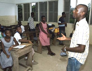
Education
Presently, Ghana has 18,530 primary schools, 8,850 junior secondary schools, 900 senior secondary schools, 28 training colleges, 20 technical institutions, 4 diploma-awarding institutions, 6 public universities and over 10 private universities.
Most Ghanaians have relatively easy access to primary and secondary education. These numbers can be contrasted with the single university and handful of secondary and primary schools that existed at the time of independence in 1957. Ghana's spending on education has varied between 28 and 40 percent of its annual budget in the past decade. All teaching is done in English, Ghana's official language.
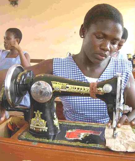
A Dora textile group in Nsawam
Ghana has a 6-year primary education system beginning at the age of six, and, under the educational reforms implemented in 1987, they pass on to a 3-year junior secondary system all making up the basic education and then afterwards a three year senior secondary system. The new educational reforms programme which was introduced in 2007 has now replaced the previous system. Now the junior secondary school is now junior high school (JHS). At the end of the 3rd year of JHS, there is a Basic Education Certificate Examination (BECE). Those continuing must complete the 4-year senior high school (SHS) program and take an admission exam to enter university. School enrollment totals over 2 million: 1.3 million primary; 550,000 middle; 300,000 secondary; 84,280 technical; 18,000 teacher training, and 89,000 in university.
The shortage of places in post-secondary education is acute; one out of nine senior secondary graduates finds a place in a technical, teacher-training, or four-year university program.
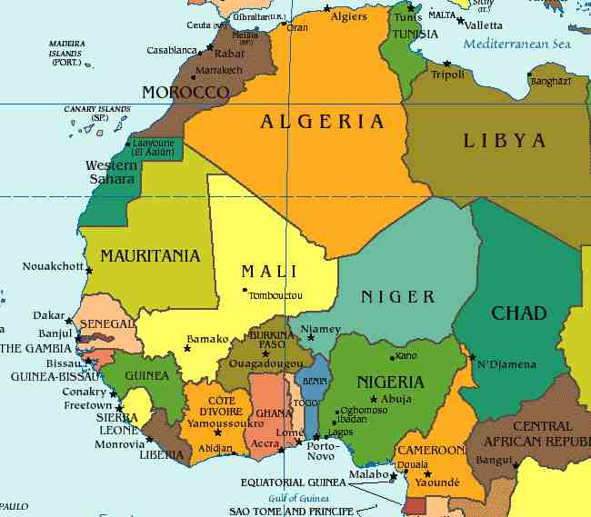
Map
of West Africa
LINKS
and REFERENCE
-
http://www.emefa.myserver.org/Ghana.mp3
-
The
World Factbook
-
International
Monetary Fund Report for Selected Countries and Subjects
-
Jackson,
John G. Introduction to African Civilizations, 2001. Page 201.
-
MacLean,
Iain. Rational Choice and British Politics: An Analysis of Rhetoric
and Manipulation from Peel to Blair, 2001. Page 76.
-
Peter
N. Stearns and William Leonard Langer. The Encyclopedia of World
History: Ancient, Medieval, and Modern, Chronologically Arranged,
2001. Page 1050.
-
Interview
with John Stockwell in Pandora's Box: Black Power (Adam Curtis,
BBC Two, 22 June 1992)
-
http://www.state.gov/www/about_state/history/vol_xxiv/s.html,
http://www.state.gov/www/about_state/history/vol_xxiv/s.html,
http://www.ghanaweb.com/GhanaHomePage/history/cia_nkrumah.php,
http://www.ghanaweb.com/GhanaHomePage/features/artikel.php?ID=75990,
On Nkrumah assassination by CIA: Gaines, Kevin (2006) American
Africans in Ghana, Black expatriates and the Civil Rights Era, The
University of North Carolina Press, Chapel Hill.
-
"Government
and Politics". A
Country Study: Ghana (La Verle Berry, editor). Library of
Congress Federal
Research Division (November 1994). This article incorporates
text from this source, which is in the public domain.[1]
-
The
World Factbook
-
[2]
-
RIGZONE
- Kosmos Makes Second Oil Discovery Offshore Ghana
-
The
World Factbook
-
Facts
on People of Ghana, accessed July 13, 2006
-
Historical
Dictionary Of Women In Sub-Saharan Africa By Kathleen E. Sheldon. 109.
-
(1995)
in LaVerle Berry: Ghana:
A Country Study. Federal Research Division, Library of
Congress, 81-82. ISBN 0844408352.
-
Heritage
Foundation - 2007 Index of Economic Freedom. Official Website
for the Index. The Wall Street Journal and The Heritage
Foundation. “The highest form of economic freedom provides an
absolute right of property ownership, fully realised freedoms of
movement for labour, capital, and ghana rocks goods, and an absolute
absence of coercion or constraint of economic liberty beyond the
extent necessary for citizens to protect and maintain liberty itself.
In other words, individuals are free to work, produce, consume, and
invest in any way they please, and that freedom is both protected by
the state and unconstrained by the state.”
-
Reporters
Without Borders - Worldwide Press Freedom Index 2006. Annual
Worldwide Press Freedom Index. Reporters sans frontières.
-
Corruption
Perception Index 2007. Official Website. Transparency
International e.V.
-
Human
Development Report 2006 (pdf). Annual Report. United
Nations Development Programme.
-
Global
Peace Index Rankings. Global Peace and Sustainability.
Economist Intelligence Unit, Centre for Peace and Conflict Studies,
University of Sydney, Australia and some Peace Institutes and Think
Tanks.
-
Table
1: Global Competitiveness Index rankings and 2005 comparisons (pdf).
World Economic Forum - Global Competitiveness Report 2006 - 2007.
World Economic Forum.
- Ghana
News
- Government
- Healthcare
-
Korle
Bu Hospital
-
Unite
For Sight at Buduburam Refugee Camp, Ghana A Unite For Sight video
documentary with interviews of residents at Buduburam Refugee Camp,
Ghana. Unite For Sight provides free eye care for the residents.
-
Subayo
Foundation A not for profit charity for women and children in
Ghana based out of the US.
-
Ghana
Eye Foundation A Non Governmental Organisation to create awareness
and mobilise resources to support the provision of a sustainable,
equitable and quality eye health service by well-trained and
appropriately motivated personnel to all residents in Ghana.
- Overviews
- Teaching
resources
- Tourism
500ml
PET bottle
|
Adelaide
Aden
- Yemen
Afghanistan
Africa
Alaska
Algeria
Amsterdam
Antarctic
- Antarctica
Arctic
- North
Pole
Argentina
Asia
Athens
Atlantis
- Plato's Lost City
Australia
Austria
Aztecs
- Mexico
Bahamas
Bangladesh
Baghdad
Bahrain
Barbados
Beachy
Head, England
Belgium
Berlin
Bermuda
Black
Rock Desert, Nevada
Bohemia
Bolivia
Bonneville,
Utah - History
Brazil
Brighton
- West Pier
British
Columbia
Bulgaria
Burma
Canada
Canary
Islands
Cape
Hope
Cape
York - Au
Caribbean
- Central America
Cayman
Islands
Chichester
Harbour
Chile
China
- Beijing
Columbia
- S. America
Columbo
- Sri Lanka
Cowes,
Isle of Wight
Croatia
Cuba
Cyprus
Czechoslovakia
Darwin
- Australia
Daytona
Beach - Florida USA
Denmark
Dubai
Eastbounre
Pier, England
Earthquakes
Egypt
Equador
Equator
Europe
Falkland
Islands
Falmouth,
Cornwall
Fiji
Finland
Florida
France
Galapagos
Islands
Geography
Links
Geography
Records
Geography
Resources
|
Geography
Statistics
Germany
Gibraltar
- Links
Greece
Greenland
Hampshire
Hawaii
Holland
- Volendam
Hollywood,
California, LA
Hong
Kong
Hungary
Hurricanes
Iceland
India
- Mumbai
Indonesia
Links
Iran
Iraq
Ireland
Isle
of Man
Isle
of Wight
- The
Needles
Israel
Italy
Jakarta
- Java
Jamaica
Japan
Jordan
Kent,
England - Sandgate
Kenya
Korea
Kuwait
Kyoto
- Japan
Las
Vegas -
Lebanon
Libya
Life
on Earth
London
- Big
Ben
London
Eye - Madame
Tussauds
London
Houses
Parliament
London
- Buckingham
Palace
London
- Old
Bailey
London
- Overview
London
- The City
London
- Tower Bridge
London
- Trafalgar
Square
Luxembourg
Malaysia
Malta
Maya
Empire -
Central America
Melbourne,
Australia
Mexico
Middle
East
Monaco
Morocco
Mountains
Naples-
Italy
National
Geographic
Nepal
Nertherlands
- Eindhoven
New
York
New
Zealand
Nigeria
North
Africa
Norway
Nova
Scotia
Oceans
and Seas
Oman
Pakistan
Palermo
- Sicily
Palestine
|
Palma
- Malorca
Panama
Canal - Links
Paris
Pendine
Sands - Carmarthen
Peru
Philippines
Pisa
Planet
Earth
Poland
Port
Moresby - PNG
Port
Said - Egypt
Portugal
Puerto
Rico
Qatar
Quebec
Rio
de Janeiro
Romania
Rome
Russia
Salt
Lake City - Utah
Saudi
Arabia
Scotland
Senegal
West Africa
Singapore
Somalia
South
Africa
South
America
Southampton
Spain
- Espana
Sri
Lanka - Links
Stonehenge
Suez
Canal
Sudan
Surrey,
England Index
Sussex,
England Index
Sweden
Switzerland
Sydney,
Australia
Syria
Tahiti
- Polynesia
- Links
Taiwan
Thailand
Tokyo,
Japan
Tonga
- Polynesia
Toronto
Trinidad
- Lesser Antilles
Tsunami
Tunbridge
Wells, England
Tunisia
Turkey
UAE
- United Arab Emirates
UK
Statistics
Ukraine
United
Kingdom
United
Kingdom -
Gov
USA
Venezuela
Venice
Vienna
Vietnam
Volcanoes
Wales
Washington
D.C.
Wealden
iron industry
Wendover,
Utah
World
Peace Supporters
Yemen
Yugoslavia
Zurich
|
Solar
Cola drinkers care about planet
earth
..
Thirst for Life

(330ml
Planet Earth can)
|