|
ALASKA
Please use our A to Z INDEX to navigate this site
|
|||||
|
Alaska is a U.S. state, located on the northwest tier of North America. It is by far the largest state in area, but one of the least populated. It is the 49th state, having been admitted to the Union on January 3, 1959. The name "Alaska" is most likely derived from the Aleut Alyeska, meaning "great country", "mainland" or "great land".
Alaska is one of the two U.S. states not bordered by another state, Hawaii being the other. It is the only non-contiguous state in North America; about 500 miles (800 km) of Canadian territory separate Alaska from Washington. Alaska is thus an exclave of the United States that is part of the continental U.S. but is not part of the contiguous U.S. It is also the only mainland state whose capital city is accessible only via ship or air. No roads connect Juneau to the rest of the state.
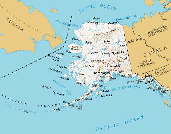
It is bordered by Yukon Territory and British Columbia, Canada to the east, the Gulf of Alaska and the Pacific Ocean to the south, the Bering Sea, Bering Strait, and Chukchi Sea to the west, and the Beaufort Sea and the Arctic Ocean to the north.
Alaska is the largest state in the United States in terms of land area (it is larger in area than all but 18 of the world's nations) at 570,374 square miles (1,477,261 km²), over twice as large as Texas, the next largest state. If a map of Alaska were superimposed upon a map of the 48 contiguous states, Alaska would overlap Texas, Oklahoma, Kansas, New Mexico and Colorado, and if the state's westernmost point were superimposed on San Francisco, California, its easternmost point would be in Jacksonville, Florida. Alaska also has more coastline than all of the contiguous U.S. combined.
One scheme for describing the state's geography is by labeling the regions:
The northeast corner of Alaska is covered by the Arctic National Wildlife Refuge, which covers 19,049,236 acres (79,318 km²).
With its numerous islands, Alaska has nearly 34,000 miles (54,700 km) of tidal shoreline. The island chain extending west from the southern tip of the Alaska Peninsula is called the Aleutian Islands. Many active volcanoes are found in the Aleutians. For example, Unimak Island is home to Mount Shishaldin, a moderately active volcano that rises to 9,980 ft (3,042 m) above sea level. The chain of volcanoes extends to Mount Spurr, west of Anchorage on the mainland.
North America's second largest tides occur in Turnagain Arm just south of Anchorage, which often sees tidal differences of more than 35 feet (10.7 m).
Alaska is home to 3.5 million lakes of 20 acres (8 ha) or larger. Marshlands and wetland permafrost cover 188,320 square miles (487,747 km², mostly in northern, western and southwest flatlands. Frozen water, in the form of glacier ice, covers some 16,000 square miles (41,440 km²) of land and 1,200 square miles (3,108 km²) of tidal zone. The Bering Glacier complex near the southeastern border with Yukon, Canada, covers 2,250 square miles (5,827 km²) alone.
The Aleutian Islands cross longitude 180°, so Alaska can be considered the easternmost state as well as the westernmost. Alaska and, especially, the Aleutians are one of the extreme points of the United States. The International Date Line jogs west of 180° to keep the whole state, and thus the entire continental United States, within the same legal day.
According to an October 1998 report by the United States Bureau of Land Management, approximately 65% of Alaska is owned and managed by the U.S. federal government as national forests, national parks, and national wildlife refuges. Of these, the Bureau of Land Management manages 87 million acres (350,000 km²), or 23.8% of the state. The Arctic National Wildlife Refuge is managed by the United States Fish and Wildlife Service.
Of the remaining land area, the State of Alaska owns 24.5%; another 10% is managed by thirteen regional and dozens of local Native corporations created under the Alaska Native Claims Settlement Act. Various private interests own the remaining land, totaling less than 1%.
Alaska is administratively divided into "boroughs," as opposed to "counties." The function is the same, but whereas most states use a three-tiered system of decentralisation - state/county/township - Alaska only uses two tiers - state/borough. Owing to the state's low population density, most of the land is located in the Unorganized Borough which, as the name implies, has no intermediate borough government of its own, but is administered directly by the state government.
For purposes of the federal census, the state is also divided into a number of artificial divisions defined geographically by the United States Census Bureau for statistical purposes only. For a list of boroughs and census areas in Alaska, see List of boroughs and census areas in Alaska.
Solar Cola drinkers care about planet earth
.. Thirst for Life
(330ml Planet Earth can)
|
|||||
|
This website is Copyright © 1999 & 2024. The bird logo and name Solar Navigator are trademarks. All rights reserved. All other trademarks are hereby acknowledged. Max Energy Limited is an educational charity.
|