|
New
York City is the largest city
in the United States and one of the world's major global
cities. Located in the state of New York, the city has a
population of over 8.1 million within an area of 321
square miles (approximately 830 km²)., making it the
most densely populated city in North America. Its
metropolitan area has a population of 18.7 million and
is one of the largest urban areas in the world.
New
York City is a center for international finance,
fashion, entertainment, and culture, with an
extraordinary collection of museums, galleries,
performance venues, media outlets, international
corporations, and financial markets. It is also home to
the headquarters of the United
Nations and to some of the world's most famous
skyscrapers.
Popularly
known as the "Big Apple,"
the city attracts large numbers of immigrants—over
one-third of its population is foreign born—as well as
people from all over the United States who come for its
culture, fast-paced lifestyle, cosmopolitanism, and
economic opportunity. It is among the most diverse
cities in the world—138 languages are spoken in Queens
alone. The city is also distinguished for having the
lowest crime rate among the 25 largest American cities.
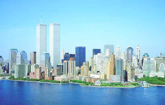
Lower
Manhattan's skyline with the Twin Towers of the World
Trade Center (1973 – 2001)
HISTORY
The
region was inhabited by the Lenape Native Americans at
the time of its discovery by Italian Giovanni da
Verrazzano. Although Verrazzano sailed into New York
Harbor, his voyage did not continue upstream and instead
he sailed back into the Atlantic
Ocean. It was not until the
voyage of Henry Hudson, an Englishman
who worked for the Dutch Republic, that the area was
mapped. He discovered Manhattan on September 11, 1609,
and continued up the river that bears his name, the
Hudson River, until he arrived at the site where New
York State's capital city, Albany, now stands. The Dutch
established New Amsterdam in 1613, which was granted
self-government in 1652 under Peter Stuyvesant. The
British took the city in September 1664, and renamed it
"New York" after the English Duke of York and
Albany. The Dutch briefly regained it in August 1673,
renaming the city "New Orange," but ceded it
permanently in November 1674.
Under
British rule the City of New York continued to develop,
and while there was growing sentiment in the city for
greater political independence, the area was decidedly
split in its loyalties during the New York Campaign, a
series of major early battles during the American
Revolutionary War. The city was under British occupation
until the end of the war and was the last port British
ships evacuated in 1783.
New
York City was the capital of the newly-formed United
States from 1788 to 1790. In the 19th century, the
opening of the Erie Canal in 1825 enabled New York to
overtake Boston and Philadelphia in economic importance,
and local politics became dominated by a Democratic
Party political machine known as Tammany Hall that drew
on the support of Irish immigrants. The New York Draft
Riots during the American
Civil War were suppressed by the Union Army. In
later years, known as the Gilded Age, the city's upper
classes enjoyed great prosperity amid the further growth
of a poor immigrant working class; it was also an era
associated with economic and municipal consolidation of
what would become the five boroughs in 1898.
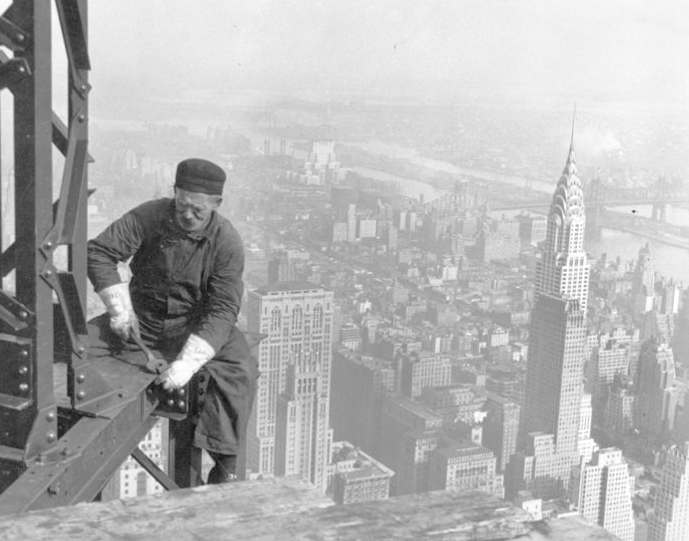
Construction
of the Empire State Building, 1930
A
series of new transportation links, most notably the
opening of the New York City Subway in 1904, helped bind
together the newly-consolidated city. The height of
European immigration brought social upheaval, and the
anticapitalist labor union IWW was fiercely repressed.
Later, in the 1920s, the city saw the influx of
African-Americans as part of the Great Migration from
the American South. The Harlem Renaissance blossomed
during this period, part of a larger boom in the
Prohibition era that saw the city's skyline transformed
by construction of dueling skyscrapers. New York
overtook London as the most populous city in the world
in 1925, ending that city's century-old claim to the
title.
The
city suffered during the Great Depression, which saw the
election of reformist mayor Fiorello LaGuardia and the
end of Tammany Hall's eighty years of political
dominance. The city's industries and port facilities,
such as the Brooklyn Navy Yard, also played a major role
in World
War II. The middle of the twentieth century also saw
a dramatic and controversial overhaul of the city's
infrastructure under the direction of Robert Moses.
New
York City emerged from World War II as the unquestioned
leading city of the world, with Wall
Street leading America's emergence as the world's
dominant economic power, the United Nations headquarters
(built in Manhattan in 1952) emphasizing its political
influence, and the rise of Abstract Expressionism
displacing Paris as center of the art world. The growth
of post-war suburbs saw a slow decline in the city's
population. Later, changes in industry and commerce,
white flight, and rising crime rates pushed New York
into a social and economic crisis in the 1970s.
The
1980s was a period of modest boom and bust, followed by
a major boom in the 1990s. Racial tensions calmed in
latter years; a dramatic fall in crime rates,
improvements in quality of life and a major
reinvigoration of immigration and growth renewed the
city, and New York's population surged past eight
million for the first time in its history. In the late
1990s, the city benefited disproportionately from the
success of the financial services industry during the dot
com boom, one of the factors driving a decade of
booming residential and commercial real estate values.
The
city was the site of a terrorist attack on September 11,
2001, when nearly 3,000 people were killed in the
destruction of the city's tallest buildings, the World
Trade Center. Among those who died were workers in the
buildings, passengers and crew on two commercial
airplanes, and hundreds of firemen, policemen, and
rescue workers who responded to the disaster. The city's
economy was substantially hurt but has since rebounded.
The Freedom Tower, intended to be exactly 1,776 feet
tall (a number symbolic of the year the Declaration
of Independence was written), is to be built on the
site and is slated for completion by 2010.
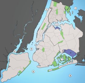
New
York City waterways: 1. Hudson River, 2. East River, 3.
Long Island Sound,
4. Newark Bay, 5. Upper New York Bay,
6. Lower New York Bay, 7. Jamaica Bay, 8. Atlantic Ocean
GEOGRAPHY
New
York City is located at the center of the BosWash
megalopolis, 218 miles (350 km) driving distance from
Boston and 220 miles (353 km) from Washington,
D.C.. The city's total area is 468.9 square miles
(1,214.4 km²), of which 35.31% is water. The city is
situated on the three major islands of Manhattan, Staten
Island, and western Long Island. The Bronx is the only
borough that is part of the mainland United States.
New
York City's significance as a trading city results from
the natural harbor formed by Upper New York Bay, which
is surrounded by Manhattan, Brooklyn, Staten Island, and
the coast of New Jersey. It is sheltered from the
Atlantic Ocean by the Narrows between Brooklyn and
Staten Island in Lower New York Bay.
The
Hudson River flows from the Hudson Valley into New York
Bay, becoming a tidal estuary that separates the Bronx
and Manhattan from New Jersey. The East River, actually
a tidal strait, stretches from the Long Island Sound to
New York Bay, separating the Bronx and Manhattan from
Long Island. The Harlem River, another tidal strait
between the East and Hudson Rivers, separates Manhattan
from the Bronx.
The
city's land has been altered considerably by human
intervention, with substantial land reclamation along
the waterfronts since Dutch colonial times. Reclamation
is most notable in Lower Manhattan with modern
developments like Battery Park City. Much of the natural
variations in topography have been evened out,
particularly in Manhattan. One possible meaning for
"Manhattan" is "island of hills"; in
fact, the island was quite hilly before European
settlement.
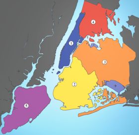
The
five boroughs: 1: Manhattan, 2: Brooklyn,
3: Queens, 4: Bronx, 5: Staten Island
Cityscape
New
York City - officially called the City of New York
- is
comprised of The Five Boroughs. Throughout the boroughs
there are hundreds of distinct neighborhoods in the
city, many with a definable history and character all
their own. If the five boroughs were five independent
cities, each would be among the United States' top 50
cities by population.
Manhattan
(New York County, pop. 1,564,798) is the business center
of the city, and the most superlatively urban. It is the
most densely populated, and the home of most of the
city's skyscrapers. The borough is loosely divided into
downtown, midtown, and uptown regions.
The
Bronx (Bronx County, pop. 1,363,198) is known as the
birthplace of hip hop culture, as well as the home of
the New York Yankees and the largest cooperatively owned
housing complex in the United States, Co-op City.
Excluding its minor islands, the Bronx is the only
borough of the city that is on the mainland of the
United States.
Brooklyn
(Kings County, pop. 2,472,523), the most populous
borough, was at one time an independent city and has a
strong native identity. It ranges from a modern business
district downtown to large historic residential
neighborhoods in the central and south-eastern areas. It
also has a long beachfront and Coney Island, famous as
one of the earliest amusement grounds in the country.
Queens
(Queens County, pop. 2,241,600 (2005 US census
estimate)) is geographically the largest borough and,
according to the US census, the most ethnically diverse
county in the United States with many immigrant
enclaves. Prior to consolidation with New York City it
was at one time composed of small towns and villages
founded by the Dutch. It is home to Shea Stadium and the
New York Mets; two of the region's three major airports;
Flushing Meadows Corona Park, site of the 1939 and 1964
World Fairs; and the USTA National Tennis Center, home
of the annual U.S. Open.
Staten
Island (Richmond County, pop. 459,737) is quiet and the
most suburban in character of the five boroughs, but has
gradually become more integrated with the rest of the
city since the opening of the Verrazano-Narrows Bridge
in 1964, an event that caused controversy and even an
attempt at secession. Until 2001, Staten Island was the
home of the infamous Fresh Kills Landfill, formerly the
largest landfill in the world, and now being
reconstructed as one of the largest urban parks in the
United States.
CLIMATE
Despite
being located at a more southern latitude than Italian
Tuscany or the French Riviera, New York has a humid
continental climate resulting from prevailing wind
patterns that bring cool air from the interior of the
North American continent.
New
York winters are typically cold but somewhat milder than
those of inland cities at a similar latitude in the
Eastern and Midwestern United States. Nighttime
temperatures range from 10 °F to 20 °F (-12 °C to -2
°C). Snowfall varies from year to year, usually
averaging about 2 ft (60 cm) in total. The winters from
2003 to 2006 have had above normal snowfall with over 3
ft (100 cm) for each season. Rain is more common than
snow in the winter, because the Atlantic Ocean helps
keep temperatures warmer than in the interior Northeast.
Springs
in New York are warm and mild, with high temperatures
averaging in the 50 °Fs (10 to 15 °C) in late March to
the lower 80 °Fs (27 °C to 30 °C) in early June.
Summers are hot and humid, with temperatures often
exceeding 90 °F (32 °C). Autumns are comfortable with
sunshine and average temperatures in the 50 °Fs (10 °C
to 15 °C). 70 °F (21 °C) days are common through
mid-October.
|
Month
|
Jan
|
Feb
|
Mar
|
Apr
|
May
|
Jun
|
Jul
|
Aug
|
Sep
|
Oct
|
Nov
|
Dec
|
Year
|
|
Avg
high °F (°C)
|
38
(3)
|
40
(4)
|
50
(10)
|
61
(15)
|
72
(22)
|
80
(27)
|
85
(30)
|
84
(29)
|
76
(24)
|
65
(18)
|
54
(12)
|
42
(6)
|
62
(17)
|
|
Avg
low temperature °F (°C)
|
25
(-4)
|
27
(-3)
|
35
(2)
|
44
(7)
|
54
(12)
|
63
(17)
|
68
(20)
|
67
(19)
|
60
(16)
|
50
(10)
|
41
(5)
|
31
(-1)
|
47
(8)
|
|
Rainfall
in. (mm)
|
3.4
(86)
|
3.3
(84)
|
3.9
(99)
|
4.0
(102)
|
4.4
(112)
|
3.7
(95)
|
4.4
(112)
|
4.1
(104)
|
3.9
(99)
|
3.6
(91)
|
4.5
(127)
|
3.9
(99)
|
46.7
(1124)
|
|
Source:
Weatherbase
|
ENVIRONMENT
New
York's unique population density poses environmental
advantages and risks. It facilitates the highest mass
transit use in the United States, but also concentrates
pollution. Citing New York's density, land use, transit
systems, watershed management and local agricultural
resources, the environmental organization SustainLane
ranked New York highest in environmental sustainability
of all U.S. cities with more than one million residents
in its 2005 US City Rankings.
Recently,
the City has enhanced its energy efficiency, reducing
demand on environmental resources, and becoming one of
the most energy efficient cities in the United States.
Gasoline consumption in the city is at the rate the
national average was in the 1920s. Since the 1990s the
city has been a national leader in municipal
environmental policy; the city government is required to
purchase only the most energy efficient cars,
air-conditioners, and copy machines. New York has the
largest clean-air diesel-hybrid and compressed natural
gas bus fleet in the country, and some of the first
hybrid taxis.
The
city is also a leader in energy-efficient
"green" office buildings, such as Hearst Tower
and 7 World Trade Center, which uses rainwater for use
in toilets and for irrigation, and has
computer-controlled heating and lighting. City planners
concerned about future electricity demand have
introduced experimental underwater turbines in the East
River to take advantage of tidal currents.
New
York City's drinking water management has positive
regional environmental implications. The city is
supplied by the vast Catskill Mountains watershed, one
of the largest protected wilderness areas in the United
States. As a result of the watershed's integrity and
undisturbed natural water filtration process, New York
is one of the few cities in the United States with
drinking water that does not require purification by
water treatment plants, and only chlorination is
necessary to ensure its purity at the tap.
Because
of concentrated traffic, air pollution is a major
problem. The United States Environmental Protection
Agency finds New York City's air to be some of the
dirtiest in the United States. Pollution varies greatly
from borough to borough, and residents of Manhattan face
the highest risk in the country of developing cancer
from chemicals in the air. The EPA analysis shows the
risk of developing lung cancer from particulate matter
in the air in Manhattan affects 0.0136% of the
population, or 136 residents out of every million.
ECONOMY
New
York City is a major center for international business
and commerce and is one of three "command
centers" for the global economy (along with Tokyo
and London).
The financial, insurance, and real estate industries
form the basis of the city's economy. New York is also
the most important center for mass media, journalism and
publishing in the United States as well as the
preeminent arts center in the country. Other important
sectors include the city's television and film industry,
second largest in the United States after Hollywood;
medical research and technology; non-profit institutions
and universities; and fashion.
The
city's stock exchanges are among the most important in
the world. The New
York Stock Exchange is the largest stock exchange in
the world by dollar volume, while the NASDAQ
is the world's largest by number of listings. Many
international corporations are headquartered in the
city, including more Fortune
500 companies than anywhere else. New York is unique
among American cities for its large number of foreign
corporations. One out of every ten private sector jobs
in the city is with a foreign company. Often this makes
the perspective of New York’s business community
internationalist and at odds with the federal
government’s foreign policy, trade policy, and visa
policy.
Specialized
manufacturing accounts for a large but declining share
of employment. Garments, chemicals, metal products,
processed foods, and furniture are some of the principal
manufacturers. New York’s fine natural harbor has
meant international shipping has always been a major
part of the city’s economy, but in recent decades most
cargo shipping has moved from the Brooklyn waterfront
across the harbor to the Port Newark-Elizabeth Marine
Terminal in New Jersey. Some cargo shipping remains;
Brooklyn still handles the majority of cocoa bean
imports to the United States.
"Creative"
industries, like design, new media, and architecture
account for a growing share of employment. With the
increasing commercial role of the city’s many medical
laboratories and research centers, science and research
is another strong growth sector. Jobs in the sector grew
4.9% in 2004–2005. High-tech industries like software
development, gaming design, and Internet services are
also growing; New York is the leading international
internet gateway in the United States because of its
position at the terminus of the transatlantic fiber
optic trunkline, with 430 gigabits/second of
international Internet capacity terminates. By
comparison, the number two U.S. hub,
Washington/Baltimore, has 158 gigabits/second of
internet terminates.
New
York City has an estimated gross metropolitan product of
nearly $500 billion within the city limits, larger than
the GDP of Switzerland
and nearly equaling that of Russia.
If it were a nation the city would have the 17th largest
economy in the world, and at $59,000 per person, New
York would have the second highest per capita GDP after Luxembourg.
|
|
|
|
Flag
|
Seal
|
|
|
Nickname:
"Big Apple"
|
|
Location
|
|
Location
in the state of New York
|
|
Government
|
|
Counties
(Boroughs)
|
Bronx
(The Bronx)
New York (Manhattan)
Queens (Queens)
Kings (Brooklyn)
Richmond (Staten Island)
|
|
Mayor
|
Michael
Bloomberg (R)
|
|
Geographical
characteristics
|
|
Area
|
|
|
City
|
1,214.4
km² (468.9 sq mi)
|
|
Land
|
785.5
km² (303.3 sq mi)
|
|
Water
|
428.9
km² (165.6 sq mi)
|
|
Urban
|
8,683.2
km² (3,352.6 sq mi)
|
|
Metro
|
17,405
km² (6,720 sq mi)
|
|
Elevation
|
10
m (33 ft)
|
|
Population
|
|
|
City
(2004)
|
8,104,079
|
|
Density
|
10,316/km² (26,720/sq mi)
|
|
Urban
|
18,498,000
|
|
Metro
|
18,709,802
|
|
Time
zone
Summer (DST)
|
EST
(UTC-5)
EDT (UTC-4)
|
|
Website:
http://www.nyc.gov/
|
NEW
YORK UPSTATE
The headwaters of the Delaware, Susquehanna, Hudson, and Allegheny rivers are located in the region. The region is characterized by the major mountain ranges, large lakes, and extensive forests.
The Allegheny Plateau extends into west and central New York from the south. The Catskill Mountains lie in the southeastern part of the state, closer to New York City. The Catskills and the Allegheny Plateau are both part of the Appalachian Mountains. The northernmost part of the state contains the Adirondack Mountains, which are sometimes considered part of the Appalachians but are geologically separate, a southern extension of the Canadian Shield.
In the more mountainous eastern part of Upstate New York, the valleys of the Hudson River and the Mohawk River were historically important travel corridors and remain so today. Western New York in the vicinity of Buffalo is very flat, as it was once the bottom of a glacial lake. The only "hills" in Niagara County are the Niagara Escarpment, which formed the Falls.
Upstate has a long shared border with Canadian province of Ontario divided by
water; including the Lake Erie, Niagara River, Lake Ontario and the St. Lawrence River. It shares a land border with the province of Quebec in the northernmost part of the state.
The sizes of upstate counties and towns are generally larger in area and smaller in population, compared with the downstate region, although there are exceptions. The state's smallest county in population (Hamilton County) and largest county in area (St. Lawrence County on the state's northern border) are both in Upstate New York, while the largest in population (Kings County) and smallest in area (New York County) are both part of New York City.
Upstate New York is well known for its cold and snowy winters, particularly in comparison to the more temperate climate of downstate New York. The snowy reputation is especially true for the cities of Buffalo, Rochester, Oswego and Syracuse, and is largely due to lake-effect snow from Lake Ontario and Lake Erie. The villages of Old Forge and Saranac Lake, both in the Adirondacks, often vie on winter nights with places like International Falls, Minnesota and Fargo, North Dakota for the coldest spot in the
nation.
Many of the features of the upstate landscape, such as the Finger Lakes and the drumlins that dot the region, are the result of glaciers during the
Ice Age.
History
Early history
Before the arrival of Europeans, the area was inhabited by Iroquoian-speaking people (mainly west of the Hudson) and Algonquian-speaking people (mainly east of the Hudson). The conflict between the two peoples was an important historical force in the days of the early European colonization. The Haudenosaunee or Iroquois confederacy of the Five (later Six) Nations was a powerful force in its home territory, having successfully eliminated the tribes of Neutral Indians, Wenrohronon and the Erie Indians in Western New York during the Beaver Wars. (Survivors were mostly assimilated into the Seneca nation; others are believed to have escaped to South Carolina.) The Five Nations' territory extended from the Mohawk River Valley to the western part of the state. From this home base they also controlled at various times large swaths of additional territory throughout what is now the northeastern United States. The Guswhenta (Two Row Wampum Treaty), made with the Dutch government in 1613, codified relations between the Haudenosaunee and European colonizers, and formed the basis of subsequent treaties.
The region was important from the first days of both French Colonization and Dutch colonization In the seventeenth century. The New Netherland colony encompassed the Hudson Valley north to the confluence of the Hudson and Mohawk Rivers, where Fort Orange (later Albany) was established in 1623 and Schenectady in 1661. The upper Hudson Valley was the center of much of the colony's fur trade.
North and west of New Netherland, the French established trading posts as far south as the shores of Onondaga Lake. They found both trading and proselytizing difficult among the Haudenosaunee, as Samuel de Champlain had alienated the Haudenosaunee during military forays from New France. In the 1640s, three French Jesuit missionaries to New France —St. René Goupil, St. Isaac Jogues, and St. Jean de Lalande—were killed near the Mohawk village of Ossernenon, which was located near the modern town of Auriesville. They are considered to be the first three U.S. saints.
England seized New Netherland by force in 1664, renaming it New York. The Dutch recaptured the colony nine years later, but ceded it to England in the Treaty of Westminster of 1674.
In the eighteenth century, the English consolidated their hold on the region. Sir William Johnson, 1st Baronet established an estate in the Mohawk Valley, living among the Mohawks and forging an alliance with them. The English also encouraged settlement in the Mohawk Valley by other Europeans including German Palatines.
In what became known as the Albany Congress, delegates from seven of the thirteen British North American colonies met at Albany in 1754 to pursue a treaty with the Mohawks. Benjamin Franklin, a Pennsylvania delegate, proposed a plan for uniting the seven colonies that greatly exceeded the scope of the congress. The delegates spent most of their time debating this Albany Plan of union, one of the first attempts to form a union of the colonies "under one government as far as might be necessary for defense and other general important
purposes". The delegates approved an amended version, but the colonies rejected it.
To counter the French militarily, the English established forts along Lake Ontario and at portages between the Mohawk Valley and the adjacent Lake Champlain and Lake Ontario watersheds. The region was thus the scene of much of the fighting of the French and Indian War, such as the Battle of Fort Oswego (1756) and the Siege of Fort William Henry (which was later depicted in the work of James Fenimore Cooper).
The English conquered New France by 1760. France formally ceded New France to the British in the Treaty of Paris of 1763. The same year, King George III issued the Royal Proclamation of 1763, which established the western and northern boundary of the Province of New York at the limits of the Hudson, Mohawk and Delaware River watersheds. The area between that boundary and the Great Lakes and Saint Lawrence River was to be the "Indian Reserve."
American Revolution
Between 1774 and 1783, deeply divided colonists waged civil war on each other directly and by proxy, through attacks such as the Seneca-led Cherry Valley and the Mohawk-led Cobleskill massacre. In 1779, the Sullivan Expedition, a campaign by the Continental Army ordered by Gen. George Washington, drove thousands of the Haudenosaunee from their villages, farms and lands in the region in an effort to both avenge and prevent such attacks.
The region was strategically important to the war plans of both the British and the Continental armies. British efforts to divide the New England colonies from the rest led to battles between the armies including the Battle of Saratoga, a significant turning point in the war. While New York City remained in the hands of the British during most of the war, the upstate region was eventually dominated by the Colonial forces.
Post-Revolutionary Period
The Treaty of Paris that ended the American Revolution established the border between New York and British North America. The 45th Parallel became the border with Quebec or Lower Canada. The St. Lawrence River, Lake Ontario, the Niagara River and Lake Erie became the border with Upper Canada. Great Britain continued to occupy military installations along the American shores of the Great Lakes until 1794, including Fort Niagara at the mouth of the Niagara River and Fort Ontario at the mouth of the Oswego River.
The government of the new State of New York seized the property of New Yorkers who had remained loyal to the British crown. Thousands emigrated to colonies that remained under British rule, such as Nova Scotia and the newly established Upper Canada. Haudenosaunee who had fought with the British also fled. The British Crown granted a large tract of land in Upper Canada to their Haudenosaunee allies, who established the Grand River settlement.
In the federal Treaty of Canandaigua, the new United States recognized the title of the remaining Haudenosaunee to the land north and west of the Proclamation Line of 1763. Nevertheless, New York state officials and private land agents sought through the early 19th century to extinguish Indian title to these lands via non-Federally-sanctioned treaties, such as the Treaty of Big
Tree. The Treaties of Buffalo Creek were designed to finally remove the last of the native claims in Western New York as part of the federal Indian Removal program, but the purchaser failed to buy most of the land in time, and some of the tribes objected to their exclusion. Three of the four reservations remain in the region to this day; one of the reservations leased out their land to form the city of Salamanca, and the coexistence of the predominantly white city and the reservation has been a source of contention since the 1990s.
Both before and after the Revolution, boundary disputes with other colonies and their successor states also complicated American settlement. In conflict with New York Colony's claims west of the Hudson Valley, which placed the entire region in the sprawling Albany County, Pennsylvania Colony claimed much of the Southern Tier until 1774, while Massachusetts Bay Colony claimed all of the region west of Massachusetts to the Great Lakes.
The Province of New York also claimed jurisdiction east to the Connecticut River. To pursue this claim north of Connecticut and Massachusetts, New York granted lands to settlers in what is now Vermont at the same time that New Hampshire made grants of the same lands. When Vermont declared independence in 1777, the new Republic of Vermont recognized the New Hampshire grants over those of New York. New Yorkers who lost land in Vermont came to be known as the "Vermont Sufferers" and were granted new lands in 1788 in the Town of Bainbridge, New York.
The dispute with Massachusetts over lands to the west of Massachusetts was settled in the 1786 Treaty of Hartford by dividing the rights to the land. The treaty granted sovereignty to the State of New York, but granted to the Commonwealth of Massachusetts the "pre-emptive" right to seek title to the land from the Haudenosaunee. The eastern boundary of the Massachusetts lands was thus known as the Preemption Line. This line runs from the Pennsylvania line due north to Lake Ontario, passing through Seneca Lake. The line was surveyed a second time due to initial errors. The Commonwealth of Massachusetts sold this land in large tracts, including the Phelps and Gorham Purchase and the Holland Purchase.
Many of the settlers of what then became Central and Western New York came from the New England states. The Central New York Military Tract, where many of the townships were given the names of classical military and literary figures by Robert Harpur, was established to grant land to Revolutionary War veterans.
19th century
Battles of the war of 1812 (1812–1815) were fought in the Champlain Valley, including the Battle of Plattsburgh, in the St. Lawrence Valley, and on Lake Ontario, including the Battle of Sackets Harbor. After the war, the US Government began to construct Fort Montgomery just south of the border at Rouses Point on Lake Champlain. Subsequently it was discovered that at that point, the actual 45th parallel was three-quarters of a mile south of the surveyed line, putting the Fort, which became known as "Fort Blunder," in Canada. This was not resolved until 1842 with the Webster-Ashburton Treaty, in which Great Britain and the United States decided to leave the border on the meandering line as surveyed.
Slavery existed in New Netherland and the Province of New York. New York was in the 1690s the largest importer of slaves among the American colonies. Slavery did not end with the American Revolution, although John Jay introduced an emancipation bill in to the State Assembly as early as 1777. Sojourner Truth was held as a slave in the Hudson Valley from the time she was born in 1797 until she escaped in 1826. Through efforts of the New York Manumission Society and others, New York began to adopt a policy of gradual emancipation in 1799. The law passed in 1817 that would finally emancipate slaves did not take effect for ten years, giving slaveowners an entire decade to sell their
slaves away to other states. When the law finally took effect, the last 2,800
slaves in New York State were emancipated on July 4, 1827.
Although routes for travel on foot and by canoe had existed across the region for hundreds of years, transportation of agricultural goods to market was expensive and slow. Influenced by the canals being built in Britain, leading citizens of New York began to press for the construction of a canal across the state. Governor DeWitt Clinton prevailed upon the legislature to charter and fund construction of a canal from Albany to Buffalo. Construction of the Erie Canal began in 1817 and was completed in 1825. The canal allowed the area to become an important component of the 19th century industrial expansion in the United States. The canal also promoted trade with
British North America and settlement of newer states in western territories. Later in the century the New York Central Railroad followed the "water-level route" from New York City to the Great Lakes, contributing to the industrialization of cities along its route.
Several times in the nineteenth century, Upstate New York served as a staging area and refuge for Canadian rebels against Great Britain, as well as Irish-American invaders of Canada, straining British-American relations. In 1837 and 1838, in the aftermath of the Lower Canada Rebellion, some Québécois rebels escaped south to the North Country, while on the Niagara Frontier, events of the Upper Canada Rebellion, also known as the Patriot War, took place. In the late 1860s, some of the Fenian Raids were launched across the Niagara Frontier; Fenians also assembled in Malone.
Although now largely discredited, the report of the 1905-1907 Mills Commission, charged with investigating the origins of baseball, named Cooperstown as the place where baseball was invented in the 1830s or 1840s by Abner Doubleday. Cooperstown is the home of the National Baseball Hall of Fame and Museum.
In the pre-Civil War era, Upstate New York became a major center of radical abolitionist activity and was an important nexus of the Underground Railroad. Resistance to the Fugitive Slave Act was particularly heated in the region, as evidenced by such events as the Jerry Rescue. The American women's rights movement was also born in Upstate New York at this time; the first women's rights convention was held at Seneca Falls in 1848.
Through the nineteenth century, Upstate New York was a hotbed of religious revivalism. A number of sects, such as the Shakers and the Oneida Community, established themselves in Upstate New York during that time. This led evangelist Charles Grandison Finney to coin the term the "Burned-Over District" for the region. Because of the comparative isolation of the region, many of the sects were non-conformist, and because of their non-traditional tenets they had numerous difficulties with government and other local people. The region is considered to be the cradle of Mormonism, as well as the Women's Suffrage movement. The Mormons, Seventh-day Adventists and Spiritualists are the only 21st century survivors of the hundreds of sects created during this time.
In the 19th century, extractive industries changed the landscape. Potash was manufactured as the land was cleared for farming. Logging was rampant in the Adirondacks. Iron was mined in the Adirondacks and the North Country. By the 1870s, business leaders, concerned about the effect of
deforestation on the
water supply necessary to the Erie Canal, advocated for the creation of forest preserves in the Adirondacks and the Catskills. The Adirondack Park and Catskill Park were created and strengthened by a series of legislation between 1885 and 1894, when the "Forever wild" provision of the New York State Constitution was added.
20th century
During the era immediately following World War
II, Upstate reached what was probably its peak influence in the national economy. Major local corporations such as IBM, General Electric, Kodak, Xerox and Carrier produced cutting edge products for business, government and consumers. The opening of the New York State Thruway in the mid 1950s gave the region superior access to other eastern markets. This regional advantage faded as many local firms relocated operations to other states, or downsized in the face of foreign competition, similar to other areas in the American Rust Belt.
In recent decades, with the decline of manufacturing, the area has generally suffered a net population loss. In contrast, many Amish and Mennonite families are recent arrivals to the area. Beginning in 1974, many Mennonite families moved to the Penn Yan area of Yates County from Lancaster County, Pennsylvania, seeking cheaper farmland. Recently established Amish communities are in St. Lawrence, Montgomery, Chautauqua and Cattaraugus counties.
Additionally, Upstate New York continues to boast low crime rates, high educational prospects, and readily affordable daily essentials, earning Syracuse, New York, Rochester,
New York, Albany, New York, Schenectady, New York, and Buffalo, New York spots in the Forbes magazine list of top ten places to raise a family in the United States.
Five of the six Iroquois nations have filed land claims against New York State (or have sought settlement of pending claims), based on late 18th-century treaties with the State of New York and the United States.
Politics
Often attributed to the region's semi-rural character, there is more conservatism in culture and politics than found in the more urban downstate area, and is the power base of the state's Republican Party. Upstate New York does however have several Democratic counties including Erie County (Buffalo), Monroe County (Rochester), Onondaga County (Syracuse), Tompkins County (Ithaca), Albany County (Albany), Broome County (Binghamton), Clinton (Plattsburgh), Franklin County (Malone), St. Lawrence County (Massena, Potsdam, Ogdensburg) and Ulster County (Kingston, Woodstock, New
Paltz).
As a whole, Upstate New York is roughly equally divided in Federal elections between Democrats and Republicans. In 2004, John Kerry defeated George W. Bush by fewer than 1,500 votes (1,553,246 votes to 1,551,971) in the Upstate Region.
NEW
YORK DOWNSTATE
Downstate New York is a term denoting the southeastern portion of New York State, United States, in contrast to Upstate New York. The term "Downstate New York" has less currency than its counterpart term "Upstate New York." The Downstate region, like Upstate New York, is divided into several subregions - New York City, Long Island, and the northern suburbs of New York City (usually consisting of Westchester County and Rockland County). The northern boundary is extended by some definitions to include all or some of Putnam County, Orange County, and Dutchess County.
The Downstate region contains the largest population concentration in the state, unlike Upstate, an area which forms the vast majority of the state's land area yet has a smaller population. The two regions differ culturally and socially in terms of demographics, economy, and social patterns.
Definitions
The New York State Department of Transportation defines its "downstate region" as including Dutchess and Orange counties, and areas east and
south.
As usual with regions, there is no definitive or permanent boundary between Upstate and Downstate New York, though the map on the right sums up common attitudes of New Yorkers regarding the location of the borderline. In general, the differing definitions of Upstate and Downstate are largely relative. Persons living further upstate generally consider the border with downstate to be further north than those who live downstate, and vice versa. As urban sprawl progressively converts previously rural communities into exurbs, many people increasingly consider neighboring Putnam County to be part of the Downstate region, as well as the southern portions of Orange County, Sullivan County, and Dutchess County. These transitional areas are colored orange on the map.
|
Helicopter
ride - Youtube
|
New
York - Youtube
|
|
24
hour city - Youtube
|
NY
Time Lapse - Youtube
|
THE
STATUE OF LIBERTY
The
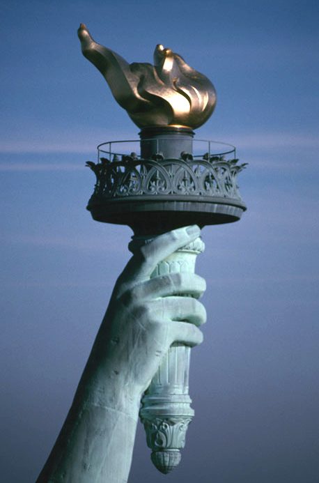
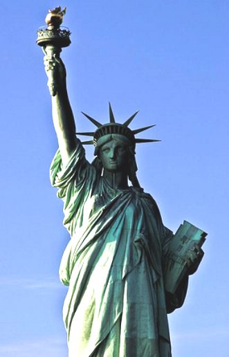
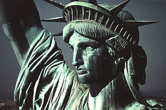
Statue of Liberty (Liberty Enlightening the World; French: La Liberté éclairant le monde) is a colossal neoclassical sculpture on Liberty Island in New York Harbor, designed by Frédéric Bartholdi and dedicated on October 28, 1886. The statue, a gift to the United States from the people of France, is of a robed female figure representing Libertas, the Roman goddess of freedom, who bears a torch and a tabula ansata (a tablet evoking the law) upon which is inscribed the date of the American Declaration of Independence, July 4, 1776. A broken chain lies at her feet. The statue is an icon of freedom and of the United States: a welcoming signal to immigrants arriving from abroad.
Bartholdi was inspired by French law professor and politician Édouard René de Laboulaye, who commented in 1865 that any monument raised to American independence would properly be a joint project of the French and American peoples. Due to the troubled political situation in France, work on the statue did not commence until the early 1870s. In 1875, Laboulaye proposed that the French finance the statue and the Americans provide the pedestal and the site. Bartholdi completed the head and the torch-bearing arm before the statue was fully designed, and these pieces were exhibited for publicity at international expositions. The arm was displayed at the Centennial Exposition in 1876 and in New York's Madison Square Park from 1876 to 1882. Fundraising proved difficult, especially for the Americans, and by 1885 work on the pedestal was threatened due to lack of funds. Publisher Joseph Pulitzer of the World started a drive for donations to complete the project that attracted more than 120,000 contributors, most of whom gave less than a dollar. The statue was constructed in France, shipped overseas in crates, and assembled on the completed pedestal on what was then called Bedloe's Island. The statue's completion was marked by New York's first ticker-tape parade and a dedication ceremony presided over by President Grover Cleveland.
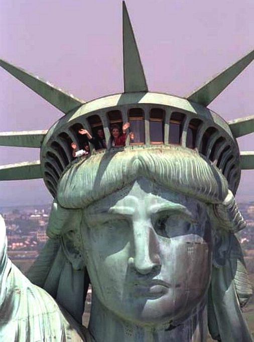
The statue was administered by the United States Lighthouse Board until 1901 and then by the Department of War; since 1933 it has been maintained by the National Park Service. The statue was closed for renovation for much of 1938. In the early 1980s, it was found to have deteriorated to such an extent that a major restoration was required. While the statue was closed from 1984 to 1986, the torch and a large part of the internal structure were replaced. After the September 11 attacks in 2001, it was closed for reasons of safety and security; the pedestal reopened in 2004 and the statue in 2009, with limits on the number of visitors allowed to ascend to the crown. The statue, including the pedestal and base, was closed for a year until October 28, 2012, so that a secondary staircase and other safety features could be installed; Liberty Island remained open. However, one day after the reopening, Liberty Island closed due to the effects of Hurricane Sandy, and the island remains off limits to the public. Public access to the balcony surrounding the torch has been barred for safety reasons since 1916.
|
Alabama AL
Alaska AK
Arizona AZ
Arkansas AR
California CA
Colorado CO
Connecticut CT
Delaware DE
Florida FL
Georgia GA
Hawaii HI
Idaho ID
Illinois IL
Indiana IN
Iowa IA
Kansas KS
Kentucky KY
Louisiana LA
Maine ME
Maryland MD
Massachusetts MA
Michigan MI
Minnesota MN
Mississippi MS
Missouri MO
|
Montana MT
Nebraska NE
Nevada NV
New Hampshire NH
New Jersey NJ
New Mexico NM
New York NY
North Carolina NC
North Dakota ND
Ohio OH
Oklahoma OK
Oregon OR
Pennsylvania PA
Rhode Island RI
South Carolina SC
South Dakota SD
Tennessee TN
Texas TX
Utah UT
Vermont VT
Virginia VA
Washington WA
West Virginia WV
Wisconsin WI
Wyoming WY
|
STATUE
OF LIBERTY LINKS
Statue
of Liberty National Monument
Statue
of Liberty at Structurae
Statue
of Liberty-Ellis Island Foundation
"A
Giant's Task – Cleaning Statue of Liberty", Popular Mechanics
(February 1932)
Views
from the webcams affixed to the Statue of Liberty
|
Adelaide
Aden
- Yemen
Afghanistan
Africa
Alaska
Albania
Algeria
Amazon
Rainforest
Amsterdam
Antarctic
Arctic
North Pole
Argentina
Asia
Athens
Atlantis
- Plato's Lost City
Australia
Austria
Aztecs
- Mexico
Baghdad
Bahamas
Bahrain
Bangladesh
Barbados
Beachy
Head, England
Belgium
Benin
Berlin
Bermuda
Black
Rock Desert
Bohemia
Bolivia Bonneville
Utah History
Bonneville,
Utah, USA
Brazil
Brighton
- West Pier
British
Columbia
Buckingham
Palace
Bulgaria
Burkina
Faso
Burma
California
Canada
Canary
Islands
Cape
Horn
Cape
Verde
Cape
York - Au
Caribbean
Cayman
Islands
Central
Africa
Chichester
Harbour
Chile
China
Columbo
- Sri Lanka
Columbia
Corfu
Cowes,
Isle of Wight
Croatia
Crooked
Island, Bahamas
Cuba
Cyprus
Czechoslovakia
Darwin
- Australia
Daytona
Beach
Denmark
Eastbounre
Pier, England
Earthquakes
Ecuador
Egypt
Eindhoven Estonia
Equator
Europe
Falkland
Islands
Falmouth,
Cornwall
Fiji
Finland
France
Galapagos
Islands
Geography
Links
Geography
Mountains
Geography
Records
Geography
Resources
Geography
Statistics
|
Germany
Ghana
Gibraltar
- Links
Greece
Greenland
Guinea
Guinea
Bissau
Hawaii
Holland
the Nertherlands
Hollywood,
California, LA
Hong
Kong
Hungary
Hurricanes
Iceland
India
Indonesia
Links
Iran
Iraq
Ireland
Isle
of Man
Isle
of Wight
- The
Needles
Israel
Italy
Ivory
Coast
Jakarta
- Java
Japan
Johannesburg
Jordan
Kent,
England
Kenya
Korea
Kuwait
Kyoto
Lanzarote,
Gran Canaria
Las
Vegas
Lebanon
Liberia
Libya
Liechtenstein
Life
on Earth
Lithuania
London
- Big
Ben
London
Eye
London
Houses
Parliament
London
- Buckingham
Palace
London
- Old
Bailey
London
- Overview
London
- The City
London
- Tower Bridge
London
- Trafalgar
Square
Luxembourg
Madame
Tussauds
Malaysia
Mali
Malta
Marshal
Islands
Mauritania
Maya
Empire -
Central America
Melbourne,
Australia
Middle
East
Melbourne,
Australia
Mexico
Monaco
Morocco
Mountains
Mumbai
Naples-
Italy
National
Geographic
Nepal
New
York
New
Zealand
Niger
Nigeria
North
Africa
Norway
Nova
Scotia
Oceans
and Seas
Oman
Pakistan
Palermo
- Sicily
Palestine
Palma
- Malorca
|
Panama
Canal - Links
Paris
Pendine
Sands
Peru
Philippines
Pisa,
Leaning Tower
Planet
Earth
Poland
Port
Moresby - PNG
Port
Said - Egypt
Portugal
Puerto
Rico
Qatar
Quebec
Rio
de Janeiro
Romania
Rome
Russia
Salt
Lake City
Samoa
Saudi
Arabia
Scandanavia
Scotland
Senegal
Siera
Leone
Singapore
Solomon
Islands
Somalia
South
Africa
South
America
Southampton
Spain
- Espana
Sri
Lanka - Links
Stonehenge
Sudan
Suez
Canal
Sundancer
Holiday Resort
Sussex,
England Index
Sweden
Switzerland
Sydney,
Australia
Syria
Tahiti
- Polynesia
- Links
Tahitian
- Men & Women Customs
Taiwan
Thailand
The
Gambia
Togo
Tokyo,
Japan
Tonga
- Polynesia
Toronto
Trinidad
- Lesser Antilles
Trinidad
and Tobago
Tsunami
Tunbridge
Wells, England
Tunisia
Turkey
Tuvalu
Islands
UAE
- United Arab Emirates
UK
Statistics
Ukraine
United
Kingdom
United
Kingdom -
Gov
USA
Uruguay
Vanuatu
Islands
Vatican
City
Venezuela
Venice
Vienna
Vietnam
Volcanoes
Volendam
Wales
Washington
D.C.
WAYN
Where Are You Now
Wealden
iron industry
Wendover
West
Africa
World
Peace Supporters
Yemen
Yugoslavia
Zurich
|

Solar
Cola drinkers care about planet
earth
..
Thirst for Life

(330ml
Planet Earth can)
A
heartwarming adventure: Pirate
whalers V Conservationists,
with
an environmental
message.
|