|
Aden
- an ancient trading centre
The
Republic of Yemen, at the south-west corner of the Arabian Peninsula,
has traded by land and sea since ancient times. Mid-way between Europe
and the Far East, Aden lies on a major world trading route through the
Suez Canal. It is one of the largest natural harbours in the world
with an area of about 70 km2 of sheltered water surrounded by Jebel
Shamsan, Khormaksar, and the shore which extends to the hills of
Little Aden. The Port of Aden consists of the Inner Harbour, the Oil
Harbour serving Aden Refinery and the anchorage and approach channels
of he Outer harbour.

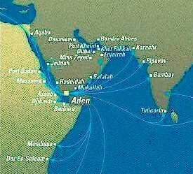
Map
showing Aden
The
City of Aden draws its vitality from the Port of Aden. The story of
Aden as a trading centre stretches back over 3000 years. Marco Polo
and Ibn Batuta visited it in the 11th and 12th Centuries. In the
1800's, Aden grew as ship fuelling port, holding stocks of coal and
water supplies for the early steamers. Port services expanded after
the Suez Canal opened in 1869 as Aden grew to become one of the
busiest ship bunkering and tax-free-shopping and trading ports in the
world by the 1950's. Barges took cargo between ships berthed in the
Inner Harbour and the wharves. Coastal vessels and dhows carried
cargoes to and from regional ports.
In
the 1970's, with the Suez Canal closed until 1975, Aden declined under
intense competition from new ports in the region and changes in the
patterns of trade. New quays were urgently needed at Aden to serve
modern cargo demands. These were built at the end of the 1980's at the
"Ma'alla Terminal". After over 150 years of commercial
activity, Aden finally had the capacity and equipment to handle all
types of dry cargo at deep alongside berths served by modern container
cranes.

Unity in 1990
formed a nation of some 15 million people with the benefits of growing
oil production and large gas reserves. Significant and positive
changes in the country are leading to rapid privatization, higher
investment and growing manufacturing output to meet national and
overseas demand. The advantages of Aden for container transhipment
have been recognized and throughput at the Ma'alla Terminal has grown
from less than 10,000 TEU's in 1994 to over 100,000 in 1998/99.
Aden
is recognized as a national resource with great potential, described
as "Yemen's Gateway to the World". To handle the world's
largest container vessels, the Aden Container Terminal (ACT) at the
North Shore of Aden's Inner Harbour was designed and built. This
facility was commissioned in March 1999 and provides the port with
world-class container handling facilities.
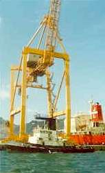
The Aden Container Terminal has two container berths, each 350
meters in length, depth 16.0 m alongside. The berths are equipped with
four 40 tones capacity (under the spreader) Reggiani super post-Panamax
shore gantry cranes (1999), with a 52 meters outreach from the quay
wall.
The
container yard covers a total area of 35 hectares, and has 2500 x 20
foot ground slots with a storage capacity of 10,000 TEU (four high).
Eight 40 tones Fels Cranes RTG's (1999), 4+1 high, 6+1 wide, and 2
reach stackers handle containers in the yard. 22 tractor units and 45
trailers move containers from the quay to the yard.
The yard has 252 reefer container power points. A 97 m x 48 m CFS
and multi-county consolidation shed, with office space, is located to
the rear of the container yard, together with terminal offices,
independent power station (14 MW), desalination plant, workshops and
waste treatment plant. The ACT operates a fleet of service,
maintenance and emergency vehicles.
Oil
harbour
Aden
Refinery Company (ARC) had an annual production of refined products of
around 4.6 million tones in 1998.
Oil products are used in Yemen and also exported by tanker.
RoRo
berth
Little Aden Oil Harbour. One RoRo berth, ramp width 20 m, located on
the NE corner of the dry cargo berth, depth 11.0 meters. Ships moor
stern to this berth, with a distance of 200 meters from the face of
the berth to the closest point of the 11.0 metre dredged area.

Lat
12° 47’N
Long 044° 58’E
Time Zone
GMT +3
Port
limits
All
the sea area north of a line from Round Island to a position 12.5
cables on a bearing 198° from Round Island to Latitude 12° 44.0’N,
45° 00’E, thence 6.3 nm on a bearing of 267° to Ras Abu Qiyamah.
Sea
buoys, fairways and channels
The
Aden and Little Aden peninsulas are very prominent, with the harbour
between them. Approaching
from the W, pass 1 nm south of Little Aden Peninsula and then to the
entrance to the dredged channel at 12° 44.5’ N, 044° 57’ E
marked by the No. 1 buoys (QR and QG).
At night, with Elephant’s Back light (red and white sectored)
on a bearing of not greater than 061° (white sector) a ship will
clear the Little Aden Peninsula on a course to bring her close to the
port entrance.
Approaching
from the E, pass 1 nm south of the Aden Peninsula and then to the
channel entrance.
At night, pass 1.5 nm S of Ra’s Marshaq light and then steer
W to the entrance to the channel.
From the No. 1 buoys, the two harbours are approached by a
dredged channel 16.0 m in depth, width 220 m.
From the bifurcation point, the channel to Little Aden oil
harbour has a depth of 14.7 m, width 220 m, length 2.3 nm, marked by
pairs of buoys. Vessels should proceed mid-way between these buoys,
and immediately after passing No. 2 buoys, turn to head 300° on the
leading marks for the centre of the channel to pass north of the oil
harbour breakwater.
Aden
inner harbour is approached by the same dredged channel, which divides
at Buoy No. 3 (S Cardinal), 9 cables north of the channel entrance.
From this point, the inner harbour channel has a depth of 15.0
m, width 185 m and is 2.6 nm to the inner harbour breakwater.
Vessels proceed on a course of 027° to pass between No. 2
Buoys, then on a heading of 047° between the channel buoys to clear
the inner harbour breakwater.
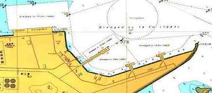
The 15.0 m deep dredged channel in the inner harbour is 220 m
wide and leads, on a heading of 068°, to the 700 m diameter turning
area off the ACT. Ships
proceeding to Ma’alla should then pass from the south side of the
turning area between buoys Nos 9 starboard and 9 port.
Pilot
Pilotage
is compulsory for all vessels over 200 GRT entering or leaving (with
certain exceptions). The
pilot station for the oil harbour and for deep draft vessels bound for
the inner harbour is at the channel entrance.
The pilot station for other vessels proceeding to the inner
harbour is by No. 1 buoys 9 cables NNE of the point where the oil
harbour and inner harbour channels divide.
All
vessels arriving off the port and wishing to enter must show the
standard international signal to request a pilot.
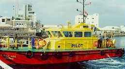
Pilot boats have red hulls and yellow superstructures.
They exhibit the standard international pilot signal at night.
A pilot ladder should be rigged on the port side by the ship
during the NE Monsoon period (mid-September to May).
During the SW monsoon (June to mid-September), pilot ladders
should be rigged on the port side for ships approaching from the W and
on the starboard side for ships approaching from the E.

Anchorage
Anchorage
areas are available for ships in the outer harb, with depths of from 6 to 20
meters in good holding ground. Anchorage
areas are not marked on the chart at present.
Smaller vessels can anchor to the north of the oil harbour approach
channel and west of the inner harbour approach channel.
Vessels with a draft of ten meters or more can anchor to the south of
the oil harbour approach channel and west of the approach channel to both
harbours. Anchorage is
prohibited within a radius of 5 cables of the channel entrance and within
2 cables of any port approach channel.
Vessels are warned that many disused cables exist in the area between Ras
Tarshayn and Jazirat Salil. A
fiber-optic cable is laid from south of the port entrance to the shore (see
Admiralty Chart No. 7).
A
yacht anchorage is available in the inner harbour between the Prince of Wales/Abkhari
Pier and the dolphin oil berth north of this.
Large yachts may anchor in the anchorage south of the western end of
the rubble mound.
The
Port of Aden is situated between the promontories of Aden (Jebel Shamsan, 553
m) and Little Aden (Jebel Muzalqam, 374 m) and is protected from the NE and SW
monsoons by these hills and along the northern boundary by land, enabling it
to operate without restriction all year. The harbour covers an area some 8 nm
east-west and 3 nm north-south.
The port consists of the outer harbour, providing anchorage areas, the oil
harbour at Little Aden on the west side of the harbour, and the inner harbour
to the east. These harbours are reached by a channel from the entrance mid-way
between the promontories. The outer section of the channel has a depth of 16.0
m. From the bifurcation point, a channel heading north west to the Little Aden
oil harbour has a depth of 14.7 m, leading to four berths for oil tankers at
depths of between 11.6 and 15.8 m, alongside LPG and dry cargo berths, and a
RoRo berth, all at a depth of11.0 meters.
The
channel to the inner harbour, leading north east from the bifurcation point,
has a least depth of 15.0 m. The inner harbour has 9 alongside berths, plus 6
buoy and 3 bunkering (dolphin) berths with depths between 5.5 and 11.9 m. On
the north side of the inner harbour, the Aden Container Terminal (ACT)
provides 700 meters of quay, depth alongside 16.0 meters (completed in March
1999). Off the ACT is a turning area, depth 15.0 m, diameter 700 m. At the
eastern end of the inner harbour, a short channel of depth 11.0 m leads to the
Ma'alla Terminal, with 4 container/general/bulk berths of total length 750 m,
depth 11.0 m., and a RoRo berth depth 7.6 m. At the eastern end of this
terminal is the Home Trade Quay, 250 m long, depth 6.7 m . The inner harbour
also contains a fishing harbour and a ship repair yard with two floating
docks.
The inner harbour is protected by a short breakwater at Ras Marbut, where the
harbour control tower is situated. The Harbour Master's office is in the
tower. 50,000 tone capacity bulk silos and a flour milling plant have
been constructed at Ma'alla (1999).
Other
services & facilities
Passenger/cruise berths, calls
by Naval Vessels 23 passenger vessels called at Aden in 1998. These use
the two bunkering dolphins on the south side of the harbour opposite the
tourist pier. Passenger launches are available to transfer passengers to
and from the ships, but they may also use their own launches. Naval
vessels from America, France, Germany, Holland, India, Oman and the UK
have recently called at Aden. These use the RoRo and main berths at
Ma'alla and/or the port's bunkering facilities.
Facilities
Ship repair, bunkering,
towage, dry-docking, launch service, medical facilities, fresh water,
dirty ballast reception, gray/black water reception, rubbish collection,
provisions, repatriation, marine/engineering surveys, gyro/radio
repairs, life raft repairs and surveys.
|
LEG
|
NAUTICAL
MILES
|
BUNKERING
|
WAYPOINT
|
SUNSHINE
DAYS
|
|
-
|
-
|
-
|
-
|
-
|
|
|
-
|
-
|
-
|
-
|
|
-
|
-
|
FILL
UP
|
Gibraltar
|
00.00
|
|
1
|
729
|
-
|
Tenerife,
Canary Islands
|
1.90
|
|
2
|
3,154
|
-
|
Trinidad,
Port of Spain
|
8.21
|
|
3
|
1,182
|
1
|
Panama
City
|
3.00
|
|
4
|
970
|
-
|
Galapagos
|
2.45
|
|
5
|
3,640
|
-
|
Tahiti
|
9.48
|
|
6
|
1,423
|
-
|
Tonga,
Nukualofa
|
3.71
|
|
7
|
410
|
-
|
Fiji,
Suva
|
1.07
|
|
8
|
1,886
|
1
|
Port
Moresby PNG
|
4.91
|
|
9
|
340
|
-
|
Thursday
Island, Cape York
|
0.88
|
|
10
|
724
|
-
|
Darwin
|
1.89
|
|
11
|
1,572
|
-
|
Jakarta,
Indonesia
|
4.09
|
|
12
|
1,881
|
-
|
Colombo,
Sri Lanka
|
4.90
|
|
13
|
2,109
|
1
|
Aden,
Yemen
|
5.49
|
|
14
|
698
|
-
|
Jeddah,
Saudi Arabia
|
1.82
|
|
15
|
670
|
-
|
Port
Said, Egypt
|
1.75
|
|
16
|
1,111
|
-
|
Palermo,
Sicily
|
2.89
|
|
17
|
170
|
-
|
Naples,
Italy
|
0.44
|
|
18
|
940
|
|
Gibraltar
|
2.45
|
|
-
|
-
|
-
|
-
|
-
|
|
-
|
23,609
|
-
|
RUNTIME
DAYS @ 12.5kts
|
78.70
|
|
-
|
-
|
(ADD
3 DAYS)
|
RUNTIME
DAYS @ 13kts
|
75.67
|
|
-
|
-
|
-
|
-
|
-
|
|
-
|
-
|
(ADD
4 DAYS)
|
14
KNOTS AVE INC
|
70.26
|
|
-
|
-
|
-
|
AT
15 KNOTS AVE
|
65.58
|
|
-
|
-
|
-
|
AT
16 KNOTS AVE
|
61.48
|
|
Adelaide
Aden
- Yemen
Afghanistan
Africa
Alaska
Albania
Algeria
Amazon
Rainforest
Amsterdam
Antarctic
- Scott
Arctic
North Pole
Argentina
Asia
Athens
Atlantis
- Plato's Lost City
Australia
Austria
Aztecs
- Mexico
Baghdad
Bahamas
Bahrain
Bangladesh
Barbados
Beachy
Head, England
Belgium
Benin
Berlin
Bermuda
Black
Rock Desert
Bohemia
Bolivia Bonneville
Utah History
Bonneville,
Utah, USA
Brazil
Brighton
- West Pier
British
Columbia
Buckingham
Palace
Bulgaria
Burkina
Faso
Burma
California
Canada
Canary
Islands
Cape
Horn
Cape
Verde
Cape
York - Au
Caribbean
Cayman
Islands
Central
Africa
Chichester
Harbour
Chile
China
Columbo
- Sri Lanka
Columbia
Corfu
Cowes,
Isle of Wight
Croatia
Crooked
Island, Bahamas
Cuba
Cyprus
Czechoslovakia
Darwin
- Australia
Daytona
Beach
Denmark
Eastbounre
Pier, England
Earthquakes
Ecuador
Egypt
Eindhoven Estonia
Equator
Europe
Falkland
Islands
Falmouth,
Cornwall
Fiji
Finland
Florida
France
Galapagos
Islands
Geography
Links
Geography
Mountains
Geography
Records
Geography
Resources
Geography
Statistics
|
Germany
Ghana
Gibraltar
- Links
Greece
Greenland
Guinea
Guinea
Bissau
Hawaii
Holland
the Nertherlands
Hollywood,
California, LA
Hong
Kong
Hungary
Hurricanes
Iceland
India
Indonesia
Links
Iran
Iraq
Ireland
Isle
of Man
Isle
of Wight
- The
Needles
Israel
Italy
Ivory
Coast
Jakarta
- Java
Jamaica
Japan
Johannesburg
Jordan
Kent,
England
Kenya
Korea
South Republic
Korea
North
Kuwait
Kyoto
Lanzarote,
Gran Canaria
Las
Vegas
Lebanon
Liberia
Libya
Liechtenstein
Life
on Earth
Lithuania
London
- Big
Ben
London
Eye
London
Houses
Parliament
London
- Buckingham
Palace
London
- Old
Bailey
London
- Overview
London
- The City
London
- Tower Bridge
London
- Trafalgar
Square
Luxembourg
Madame
Tussauds
Malaysia
Mali
Malta
Marshal
Islands
Mauritania
Maya
Empire -
Central America
Melbourne,
Australia
Middle
East
Mexico
Monaco
Morocco
Mountains
Mumbai
Naples-
Italy
National
Geographic
Nepal
New
York
New
Zealand
Niger
Nigeria
North
Africa
Norway
Nova
Scotia
Oceans
and Seas
Oman
Pakistan
Palermo
- Sicily
Palestine
Palma
- Malorca
|
Panama
Canal - Links
Paris
Pendine
Sands
Peru
Philippines
Pisa,
Leaning Tower
Planet
Earth
Poland
Port
Moresby - PNG
Port
Said - Egypt
Portugal
Puerto
Rico
Qatar
Quebec
Rio
de Janeiro
Romania
Rome
Russia
Salt
Lake City
Samoa
Saudi
Arabia
Scandanavia
Scotland
Senegal
Siera
Leone
Singapore
Solomon
Islands
Somalia
South
Africa
South
America
Southampton
Spain
- Espana
Sri
Lanka - Links
Stonehenge
Sudan
Suez
Canal
Sundancer
Holiday Resort
Sussex,
England Index
Sweden
Switzerland
Sydney,
Australia
Syria
Tahiti
- Polynesia
- Links
Tahitian
- Men & Women Customs
Taiwan
Thailand
The
Gambia
Togo
Tokyo,
Japan
Tonga
- Polynesia
Toronto
Trinidad
- Lesser Antilles
Trinidad
and Tobago
Tsunami
Tunbridge
Wells, England
Tunisia
Turkey
Tuvalu
Islands
UAE
- United Arab Emirates
UK
Statistics
Ukraine
United
Kingdom
United
Kingdom -
Gov
USA
Uruguay
Vanuatu
Islands
Vatican
City
Venezuela
Venice
Vienna
Vietnam
Volcanoes
Volendam
Wales
Washington
D.C.
WAYN
Where Are You Now
Wealden
iron industry
Wendover
West
Africa
World
Peace Supporters
Yemen
Yugoslavia
Zurich
|

Solar
Cola drinkers care about planet
earth
..
Thirst for Life

(330ml
Planet
Earth can)
|


