|
Tanzania, officially the United Republic of Tanzania, is a country in East Africa within the African Great Lakes region. It is bordered by Uganda to the northwest; Kenya to the northeast; the
Indian Ocean to the east; Mozambique and Malawi to the south; Zambia to the southwest; and Rwanda, Burundi, and the Democratic Republic of the Congo to the west. According to the 2022 national census, Tanzania has a population of around 62 million, making it the most populous country located entirely south of the equator.
Many important hominid fossils have been found in Tanzania. In the Stone and Bronze Age,
prehistoric migrations into Tanzania included Southern Cushitic speakers similar to modern day Iraqw people who moved south from present-day Ethiopia; Eastern Cushitic people who moved into Tanzania from north of Lake Turkana about 2,000 and 4,000 years ago; and the Southern Nilotes, including the Datoog, who originated from the present-day South Sudan–Ethiopia border region between 2,900 and 2,400 years ago. These movements took place at about the same time as the settlement of the Mashariki Bantu from West Africa in the Lake Victoria and Lake Tanganyika areas. In the late 19th century, the mainland came under German rule as German East Africa, and this was followed by British rule after
World War I when it was governed as Tanganyika, with the Zanzibar Archipelago remaining a separate colonial jurisdiction. Following their respective independence in 1961 and 1963, the two entities merged in 1964 to form the United Republic of Tanzania. Tanganyika joined the British Commonwealth and Tanzania remains a member of the Commonwealth as a unified republic.
Today, the country is a presidential constitutional republic with the federal capital located in Government City (Dodoma); the former capital, Dar es Salaam, retains most government offices and is the country's largest city, principal port, and leading commercial centre. Tanzania is a de facto one-party state with the democratic socialist Chama Cha Mapinduzi party in power. The country has not experienced major internal strife since independence and is seen as one of the safest and most politically stable on the continent. Tanzania's population comprises about 120 ethnic, linguistic, and religious groups. Christianity is the largest religion in Tanzania, with substantial Muslim and Animist minorities. Over 100 languages are spoken in Tanzania, making it the most linguistically diverse country in East Africa; the country does not have a de jure official language, although the national language is Swahili. English is used in foreign trade, in diplomacy, in higher courts, and as a medium of instruction in secondary and higher education, while Arabic is spoken in Zanzibar.
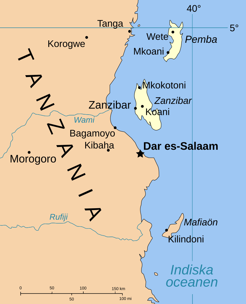
Tanzania is mountainous and densely forested in the north-east, where Mount Kilimanjaro, the highest mountain in Africa and the highest single free-standing mountain above sea level in the world, is located. Three of the African Great Lakes are partly within Tanzania. To the north and west lie Lake Victoria, Africa's largest lake, and Lake Tanganyika, the continent's deepest lake, known for its unique species of fish. To the south lies Lake Malawi. The eastern shore is hot and humid, with the Zanzibar Archipelago just offshore. The Menai Bay Conservation Area is Zanzibar's largest marine protected area. The Kalambo Falls, located on the Kalambo River at the Zambian border, is the second-highest uninterrupted waterfall in Africa. Tanzania is one of the most visited tourist destinations for safaris.
TOURISM
Travel and tourism contributed 17.5 per cent of Tanzania's gross domestic product in 2016 and employed 11.0 per cent of the country's labour force (1,189,300 jobs) in 2013. Overall receipts rose from US$1.74 billion in 2004 to US$4.48 billion in
2013, and receipts from international tourists rose from US$1.255 billion in 2010 to US$2 billion in 2016. In 2016, 1,284,279 tourists arrived at Tanzania's borders compared to 590,000 in 2005. The vast majority of tourists visit Zanzibar or a "northern circuit" of Serengeti National Park, the Ngorongoro Conservation Area, Tarangire National Park, Lake Manyara National Park, and Mount Kilimanjaro. In 2013, the most visited national park was Serengeti (452,485 tourists), followed by Manyara (187,773) and Tarangire (165,949).
OLDUVIA
GORGE - RIFT VALLEY
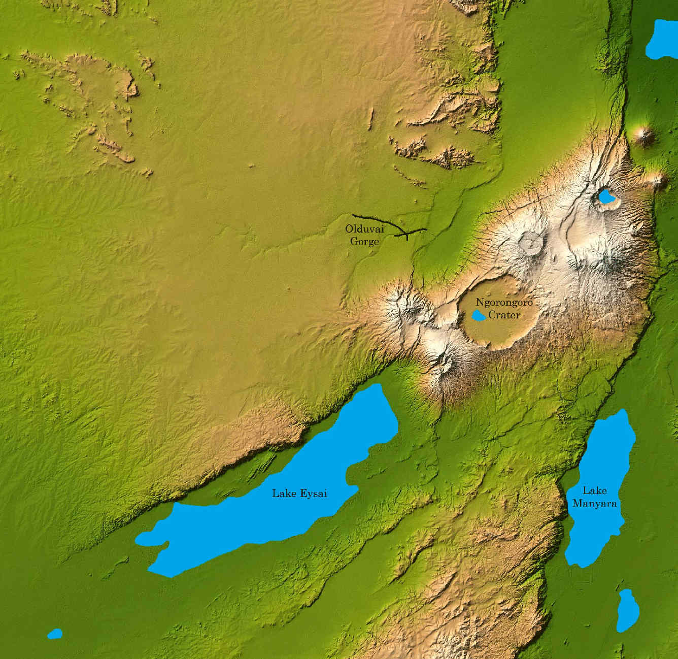
The Olduvai Gorge or Oldupai Gorge in Tanzania is one of the most important paleoanthropological localities in the world; the many sites exposed by the gorge have proven invaluable in furthering understanding of early human evolution. A steep-sided ravine in the Great Rift Valley that stretches across East Africa, it is about 48 km long, and is located in the eastern Serengeti Plains within the Ngorongoro Conservation Area in the Olbalbal ward located in Ngorongoro District of Arusha Region, about 45 kilometres (28 miles) from Laetoli, another important archaeological locality of early human occupation. The British/Kenyan paleoanthropologist-archeologist team of Mary and Louis Leakey established excavation and research programs at Olduvai Gorge that achieved great advances in human knowledge. The site is registered as one of the National Historic Sites of Tanzania.
The gorge takes its name from the Maasai word oldupai which means "the place of the wild sisal" as the East African wild sisal (Sansevieria ehrenbergii) grows abundantly throughout the gorge area. Twenty-five kilometers downstream of Lake Ndutu and Lake Masek, the gorge is the result of up to 90 meters erosion cutting into the sediments of a Pleistocene lake bed. A side gorge, originating from Lemagrut Mountain, joins the main gorge 8 km from the mouth. This side gorge follows the shoreline of a prehistoric lake, rich in fossils and early hominin sites. Periodic flows of volcanic ash from Olmoti and Kerimasi helped to ensure preservation of the fossils in the gorge.
The locality is significant in showing the increasing developmental and social complexities in the earliest Hominina, largely revealed in the production and use of stone tools. Prior to tools, evidence of scavenging and hunting can be
noted - highlighted by the presence of gnaw marks that predate cut marks -
and of the ratio of meat versus plant material in the early hominin diet. The collecting of tools and animal remains in a centralised area is evidence of developing social interaction and communal activity. All these factors indicate an increase in cognitive capacities at the beginning of the period of hominids transitioning to
homininina - that is, to human clade.
Homo habilis, probably the first early human species, occupied Olduvai Gorge approximately 1.9 million years ago (mya); then came a contemporary
australopithecine, Paranthropus boisei, 1.8 mya, followed by
Homo
erectus, 1.2 mya. Homo sapiens, which is estimated to have emerged roughly 300,000 years ago, is thought to have occupied sites in the gorge 17,000 years ago.
HANS
RECK, MARY & LOUIS LEAKEY
While travelling in German East Africa in 1911 to investigate sleeping sickness, German physician and archaeologist Wilhelm Kattwinkel visited Olduvai Gorge, where he observed many fossil bones of an extinct three-toed horse. Inspired by Kattwinkel's discovery, German geologist Hans Reck led a team to Olduvai in 1913. There, he found hominin remains which were later radiocarbon dated to 17,000 BP. Four more expeditions were planned, but World War I prevented their start. After the war, as Tanganyika came under British control, Louis Leakey visited Reck in Berlin and viewed the Olduvai fossils. Louis Leakey became convinced that Olduvai Gorge held stone tools, thinking the deposits were of similar age to the Kariandusi prehistoric site in Kenya. Reck and the paleontologist Donald McInnes accompanied Louis Leakey in his 1931 expedition, where Louis found a number of hand axes close to camp soon after their arrival. Mary Leakey first visited the area in 1935, joining Louis and Percy Edward Kent. Subsequent visits were made by the Leakeys in 1941, 1953, 1955 and 1957.
Louis and Mary Leakey are responsible for most of the excavations and discoveries of the hominin fossils in Olduvai Gorge. In July 1959, at the FLK site (the initials of the person who discovered it Frida Leakey, and K for korongo, the Swahili language word for gully), Mary Leakey found the skull of Zinjanthropus or Australopithecus boisei. In addition to an abundance of faunal remains the Leakeys found stone tools Mary classified as Oldowan. In May 1960, at the FLK North-North site, the Leakeys' son Jonathan found the mandible that proved to be the type specimen for Homo habilis.
Louis Leakey first described the Oldowan stone tool industry in 1951. The Leakeys determined that choppers were the most common stone tool found at the gorge, amounting to over half of the total number, and identified 11 Oldowan sites in the gorge, 9 in Bed I, and 2 in Bed II. They also identified the Developed Oldowan as the subsequent diverse tool-kit found in Beds II, III, and IV, with small tools made mostly from chert rather than quartzite. These tools are mostly spheroids and sub-spheroids, followed by choppers.
Besides the chert quarry in Bed II, the Leakeys were able to identify the other source locations of the principal rocks used to make the stone tools. The most common material was quartzite, which originated from the Naibor Soit Inselberg just north of the gorges. The phonolite originated from the Engelosen volcano 5 km to the north. The gneiss came from the Kelogi inselborg 9 km to the southwest.
The first species found by the Leakeys, Zinjanthropus boisei or Australopithecus boisei (renamed and still debated as Paranthropus boisei), featured a sagittal crest and large molars. These attributes suggested the species engaged in heavy chewing, indicating a diet of tough plant material, including tubers, nuts, and seeds—and possibly large quantities of grasses and sedges.
Conversely, the Leakeys' 1960s finds presented different characteristics. The skull lacked a sagittal crest and the braincase was much more rounded, suggesting it was not australopithecine. The larger braincase suggested a larger brain capacity than that of Australopithecus boisei. These important differences indicated a different species, which eventually was named Homo habilis. Its larger brain capacity and decreased teeth size pointed to Homo as the probable toolmaker.
The oldest tools at Olduvai, found at the lowest layer and classified as Oldowan, consist of pebbles chipped on one edge. Above this layer, and later in time, are the true hand-axe industries, the Chellean and the Acheulean. Higher still (and later still) are located Levallois artifacts, and finally the Stillbay implements. Oldowan tools in general are called "pebble tools" because the blanks chosen by the stone knapper already resembled, in pebble form, the final product. Mary Leakey classified the Oldowan tools according to usage; she developed Oldowan A, B, and C categories, linking them to Modes 1, 2, and 3 assemblages classified according to mode of manufacture. Her work remains a foundation for assessing local, regional, and continental changes in stone tool-making during the early Pleistocene, and aids in assessing which hominins were responsible for the several changes in stone tool technology over time.
It is not known for sure which hominin species was first to create Oldowan tools. The emergence of tool culture has also been associated with the pre-Homo species Australopithecus garhi, and its flourishing is associated with the early species Homo habilis and Homo ergaster. Beginning 1.7 million years ago, early Homo erectus apparently inherited Oldowan technology and refined it into the Acheulean industry.
Oldowan tools occur in Beds I–IV at Olduvai Gorge. Bed I, dated 1.85 to 1.7 mya, contains Oldowan tools and fossils of Paranthropus boisei and Homo habilis, as does Bed II, 1.7 to 1.2 mya. H. habilis gave way to Homo erectus at about 1.6 mya, but P. boisei persisted. Oldowan tools continue to Bed IV at 800,000 to 600,000 before present (BP). A significant change took place between Beds I and II at about 1.5 mya. Flake size increased, bifacial edges (as opposed to single-face edges) occurred more frequently and their length increased, and signs of battering on other artifacts increased. Some likely implications of these factors, among others, are that after this pivotal time hominins used tools more frequently, became better at making tools, and transported tools more often.
HUNTERS OR SCAVENGERS
Though substantial evidence of hunting and scavenging has been discovered at Olduvai Gorge, it is believed by archaeologists that hominins inhabiting the area between 1.9 and 1.7 million years ago spent the majority of their time gathering wild plant foods, such as berries, tubers and roots. The earliest hominins most likely did not rely on meat for the bulk of their nutrition. Speculation about the amount of meat in their diets is inferred from comparative studies with a close relative of early hominins: the modern chimpanzee. The chimpanzee's diet in the wild consists of only about five percent as meat. And the diets of modern hunter-gatherers do not include a large amount of meat. That is, most of the calories in both groups' diets came from plant sources. Thus, it can be assumed that early hominins had similar diet proportions, (see the middle-range theory or bridging
arguments - bridging arguments are used by archaeologists to explain past behaviors, and they include an underlying assumption of uniformitarianism.)
Much of the information about early hominins comes from tools and debris piles of lithic flakes from such sites as FLK-Zinjanthropus in Olduvai Gorge. Early hominins selected specific types of rocks that would break in a predictable manner when "worked", and carried these rocks from deposits several kilometres away. Archaeologists such as Fiona Marshall fitted rock fragments back together like a puzzle. She states in her article "Life in Olduvai Gorge" that early hominins, "knew the right angle to hit the cobble, or core, in order to successfully produce sharp-edged flakes ...". She noted that selected flakes then were used to cut meat from animal carcasses, and shaped cobbles (called choppers) were used to extract marrow and to chop tough plant material.
Bone fragments of birds, fish, amphibians, and large mammals were found at the FLK-Zinj site, many of which were scarred with marks. These likely were made by hominins breaking open the bones for marrow, using tools to strip the meat, or by carnivores having gnawed the bones. Since several kinds of marks are present together, some archaeologists including Lewis Binford think that hominins scavenged the meat or marrow left over from carnivore kills. Others like Henry Bunn believe the hominins hunted and killed these animals, and carnivores later chewed the bones. This issue is still debated today, but archaeologist Pat Shipman provided evidence that scavenging was probably the more common practice; she published that the majority of carnivore teeth marks came before the cut marks. Another finding by Shipman at FLK-Zinj is that many of the wildebeest bones found there are over-represented by adult and male bones; and this may indicate that hominins were systematically hunting these animals as well as scavenging them. The question of whether hunting or scavenging was more important at Olduvai Gorge is still a controversial one.
Direct evidence of hominins scavenging remains from a big cat in the form of antelope bones that were gnawed on by a felid and then processed by hominins has been found at David's Site from Olduvai Bed 1.
|
Adelaide
Aden
- Yemen
Afghanistan
Africa
Alaska
Albania
Algeria
Amazon
Rainforest
Amsterdam
Antarctic
- Scott
Arctic
North Pole
Argentina
Asia
Athens
Atlantis
- Plato's Lost City
Australia
Austria
Aztecs
- Mexico
Baghdad
Bahamas
Bahrain
Bangladesh
Barbados
Beachy
Head, England
Belgium
Benin
Berlin
Bermuda
Black
Rock Desert
Bohemia
Bolivia Bonneville
Utah History
Bonneville,
Utah, USA
Brazil
Brighton
- West Pier
British
Columbia
Buckingham
Palace
Bulgaria
Burkina
Faso
Burma
California
Canada
Canary
Islands
Cape
Horn
Cape
Verde
Cape
York - Au
Caribbean
Cayman
Islands
Central
Africa
Chichester
Harbour
Chile
China
Columbo
- Sri Lanka
Columbia
Corfu
Cowes,
Isle of Wight
Croatia
Crooked
Island, Bahamas
Cuba
Cyprus
Czechoslovakia
Darwin
- Australia
Daytona
Beach
Denmark
Eastbounre
Pier, England
Earthquakes
Ecuador
Egypt
Eindhoven Estonia
Equator
Europe
Falkland
Islands
Falmouth,
Cornwall
Fiji
Finland
Florida
France
Galapagos
Islands
Geography
Links
Geography
Mountains
Geography
Records
Geography
Resources
Geography
Statistics
|
Germany
Ghana
Gibraltar
- Links
Greece
Greenland
Guinea
Guinea
Bissau
Hawaii
Holland
the Nertherlands
Hollywood,
California, LA
Hong
Kong
Hungary
Hurricanes
Iceland
India
Indonesia
Links
Iran
Iraq
Ireland
Isle
of Man
Isle
of Wight
- The
Needles
Israel
Italy
Ivory
Coast
Jakarta
- Java
Jamaica
Japan
Johannesburg
Jordan
Kent,
England
Kenya
Korea
South Republic
Korea
North
Kuwait
Kyoto
Lanzarote,
Gran Canaria
Las
Vegas
Lebanon
Liberia
Libya
Liechtenstein
Life
on Earth
Lithuania
London
- Big
Ben
London
Eye
London
Houses
Parliament
London
- Buckingham
Palace
London
- Old
Bailey
London
- Overview
London
- The City
London
- Tower Bridge
London
- Trafalgar
Square
Luxembourg
Madame
Tussauds
Malaysia
Mali
Malta
Marshal
Islands
Mauritania
Maya
Empire -
Central America
Melbourne,
Australia
Middle
East
Mexico
Monaco
Morocco
Mountains
Mumbai
Naples-
Italy
National
Geographic
Nepal
New
York
New
Zealand
Niger
Nigeria
North
Africa
Norway
Nova
Scotia
Oceans
and Seas
Oman
Pakistan
Palermo
- Sicily
Palestine
Palma
- Malorca
|
Panama
Canal - Links
Paris
Pendine
Sands
Peru
Philippines
Pisa,
Leaning Tower
Planet
Earth
Poland
Port
Moresby - PNG
Port
Said - Egypt
Portugal
Puerto
Rico
Qatar
Quebec
Rio
de Janeiro
Romania
Rome
Russia
Salt
Lake City
Samoa
Saudi
Arabia
Scandanavia
Scotland
Senegal
Siera
Leone
Singapore
Solomon
Islands
Somalia
South
Africa
South
America
Southampton
Spain
- Espana
Sri
Lanka - Links
Stonehenge
Sudan
Suez
Canal
Sundancer
Holiday Resort
Sussex,
England Index
Sweden
Switzerland
Sydney,
Australia
Syria
Tahiti
- Polynesia
- Links
Tahitian
- Men & Women Customs
Taiwan
Tanzania
- The Cradle of Life, Olduvia Gorge
Thailand
The
Gambia
Togo
Tokyo,
Japan
Tonga
- Polynesia
Toronto
Trinidad
- Lesser Antilles
Trinidad
and Tobago
Tsunami
Tunbridge
Wells, England
Tunisia
Turkey
Tuvalu
Islands
UAE
- United Arab Emirates
UK
Statistics
Ukraine
United
Kingdom
United
Kingdom -
Gov
USA
Uruguay
Vanuatu
Islands
Vatican
City
Venezuela
Venice
Vienna
Vietnam
Volcanoes
Volendam
Wales
Washington
D.C.
WAYN
Where Are You Now
Wealden
iron industry
Wendover
West
Africa
World
Peace Supporters
Yemen
Yugoslavia
Zurich
|

Solar
Cola drinkers care about planet
earth
..
Thirst for Life

(330ml
Planet Earth can)
|